
Kinloss Airfield, Battle H.q.


Battlefield Headquarters (20th Century)
Site Name Kinloss Airfield, Battle H.q.
Classification Battlefield Headquarters (20th Century)
Alternative Name(s) Blackstob Wood
Canmore ID 294928
Site Number NJ06SE 29.21
NGR NJ 07583 62840
Datum OSGB36 - NGR
Permalink http://canmore.org.uk/site/294928


- Council Moray
- Parish Kinloss
- Former Region Grampian
- Former District Moray
- Former County Morayshire
NJ06SE 29.21 07583 62840
A concrete Battle HQ has been noted as located on the N side of the B 9089 road at Blackstob Wood. Originally the structure lay outside the airfield perimeter fence, but the site now falls within the security area of the airfield about 200m S of three large aircraft hangars (NJ06SE 29.11).
The structure incorporated a viewing platform with a chamber below. It is not known whether this structure survives following the addition of taxi-loops near the location provided.
A possible building which may be this Battle HQ can be seen on vertical air photographs (106G/Scot/UK 169, frame numbers 2305-2307, flown 26 August 1946) in an open field immediately S of the three aircraft hangars.
Information to RCAHMS via E-mail from Mr S Moore, Chester City Council, 2008; Information from RCAHMS (DE), 23 June 2008
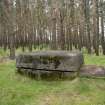
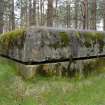
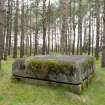
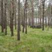
The Battle HQ is extant and was examined during the course of a photographic survey undertaken by RCAHMS between 7-9th May 2010. It is situated about 79m NE from the SW corner of Blackstob Wood (measured by tape).
It is constructed of reinforced concrete and all that is visible is the upper viewing platform with an all round slit in it for visual observation. The concrete upper works measure 2.40m square and it stands up to a height of 1.10m above the present ground level. Immediately to the NE of the uuper works is a metal plate which is one of the access shafts via a vertical metal ladder to the three underground rooms (chambers). About 6.35m NE from the upper works is another metal plate which was the main entrance via a steep flight of stairs. Both the entrances have been sealed.
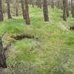
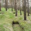
About 24.5m to the N is a small earth banked sangar and between 11m and 20m to the SW of this point are a further three small trenches and a Mg position. To the NE is a further machine gun (Mg) position, all of World War II date. It is suggested that these trenches, sangars and Mg posts are related to the Battle HQ and once formed part of the airfield defence system.
Visited by RCAHMS (DE, AL), 6 May 2010
External Reference (22 July 2013)
The bunker is in good condition as it is said to be dry inside, further investigation was not possible at the time due to health and safety concerns, the bunker is going to be sealed in the near furture.
Information from M Tucknott, 22nd July 2013

