 |
On-line Digital Images |
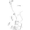
SC 390392 |
Records of the Royal Commission on the Ancient and Historical Monuments of Scotland (RCAHMS), Edinbu |
Publication drawing; Ashintully, fermtoun |
1987 |
Item Level |
|
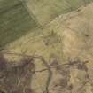 |
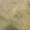
On-line Digital Images |
DP 226062 |
RCAHMS Aerial Photography Digital |
Oblique aerial view of the Ashintully township and Cnoc an Dainmh hut circles, looking WSW. |
10/3/2015 |
Item Level |
|
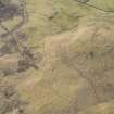 |
On-line Digital Images |
DP 226063 |
RCAHMS Aerial Photography Digital |
Oblique aerial view of the Ashintully township and Cnoc an Dainmh hut circles, looking S. |
10/3/2015 |
Item Level |
|
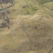 |
On-line Digital Images |
DP 226064 |
RCAHMS Aerial Photography Digital |
Oblique aerial view of the Ashintully township and Cnoc an Dainmh hut circles, looking SSE. |
10/3/2015 |
Item Level |
|
 |
On-line Digital Images |
DP 226065 |
RCAHMS Aerial Photography Digital |
Oblique aerial view of the Ashintully township and Cnoc an Dainmh hut circles, looking SE. |
10/3/2015 |
Item Level |
|
 |
On-line Digital Images |
DP 226066 |
RCAHMS Aerial Photography Digital |
Oblique aerial view of the Ashintully township and Cnoc an Dainmh hut circles, looking SE. |
10/3/2015 |
Item Level |
|
 |
On-line Digital Images |
DP 226067 |
RCAHMS Aerial Photography Digital |
Oblique aerial view of the Ashintully township, looking N. |
10/3/2015 |
Item Level |
|
 |
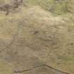
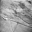
On-line Digital Images |
SC 1711085 |
RCAHMS Aerial Photography |
Oblique aerial view centred on the remains of the fermtoun with the remains of the buildings, hut circles and burnt mound, taken from the W. |
29/1/2001 |
Item Level |
|
 |
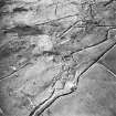
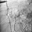
On-line Digital Images |
SC 1711086 |
RCAHMS Aerial Photography |
Oblique aerial view centred on the remains of the fermtoun with the remains of the buildings and hut circles, taken from the WSW. |
29/1/2001 |
Item Level |
|
 |
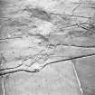
On-line Digital Images |
SC 1711087 |
RCAHMS Aerial Photography |
Oblique aerial view centred on the remains of the fermtoun with the remains of the buildings, hut circles and burnt mound, taken from the S. |
29/1/2001 |
Item Level |
|
 |
On-line Digital Images |
SC 1711088 |
RCAHMS Aerial Photography |
Oblique aerial view centred on the remains of the fermtoun with the remains of the buildings and hut circles, taken from the SE. |
29/1/2001 |
Item Level |
|
 |
On-line Digital Images |
SC 2399370 |
Records of the Ordnance Survey, Southampton, Hampshire, England |
Ashintully, NO16SW 31, Ordnance Survey index card, Recto |
1958 |
Item Level |
|


