
Broomend Of Crichie


Henge (Neolithic) - (Bronze Age)
Site Name Broomend Of Crichie
Classification Henge (Neolithic) - (Bronze Age)
Canmore ID 294046
Site Number NJ71NE 248
NGR NJ 778 197
Datum OSGB36 - NGR
Permalink http://canmore.org.uk/site/294046

- Council Aberdeenshire
- Parish Kintore
- Former Region Grampian
- Former District Gordon
- Former County Aberdeenshire
NJ71NE 248 778 197
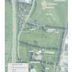
NJ 778 197 The monuments at Broomend of Crichie are located beside the River Don. Originally the prehistoric features were distributed along a gravel terrace, extending for about 500m from a conspicuous viewpoint overlooking its confluence with the Urie to what was described as a 'sand bank' commanding the valley to the S. Once there were two stone circles here, joined to one another by an avenue of paired monoliths. The larger circle seems to have incorporated a cairn, while its neighbour was enclosed by the earthworks of a henge. The avenue extended across that enclosure following a path that ran parallel to the river. Early Bronze Age burials have been recorded at several points along its course. The avenue seems to have ended beside a cist cemetery associated with early Beaker pottery and an unusual horn ladle. Most of these monuments have disappeared.
The new work in September 2006 focused on the henge which still survives. Like many monuments in the region, it was investigated by a local landowner, Charles Elphinstone Dalrymple. His report represents the henge as a perfectly circular monument, with two opposed entrances. There had been seven standing stones, six of them distributed at equal intervals around the perimeter and the other in the centre where it marked the position of a shaft grave with a cist burial on its base. Further cremation burials were at the foot of each of the monoliths.
The second excavation took place in 2005 and 2006 and has investigated the entire area enclosed by the earthwork. The project also investigated the area to its N extending as far as the 19th-century quarry. The 2005 excavation sectioned the bank and ditch on the SE side of the monument and, in 2006, it also examined the earthwork at the northern entrance. The interior of the henge has now been fully excavated, but the central pit could not be investigated because it was covered by the Pictish symbol stone put there in 1855.
The henge is more irregular than the 19th-century site plan suggests. To someone outside the monument it does appear circular and is 37m in diameter, but the interior is actually oval and measures about 16 x 21m. The perimeter is disproportionately large. The ditch was over 5m wide and between 2 and 3m deep. It was accompanied by an external bank which must have been unusually high and narrow. At the N entrance, where the ditch terminal was deepest, that bank was only 5m wide. The earthwork would have screened most of the interior of the monument from anyone outside it. The ditch was of a single phase and cut steeply into the natural gravel. It is clear that the entire earthwork was unstable and that the bank had collapsed soon after it had been built. No artefacts were associated with the earthwork, but charcoal found on the surface of the buried soil should provide a terminus post quem for its construction.
Dalrymple's plan shows the positions of seven standing stones, although only two remained in position at the time of his excavation. Excavation in 2005-6 located the positions of four stone sockets, three of which were completely excavated while the remaining example was on the edge of the excavated area where the ground had been disturbed by rabbits. The stone setting was not the perfect circle that Dalrymple suggested, but an arc of monoliths spaced at roughly equal intervals, with two large portal stones to their N. The complete 'circle' seems to have been 12m in diameter. The layout of the stone setting does not conform to the outline of the henge, and their entrances appear to be offset from one another by approximately five degrees.
Dalrymple claimed that there were cremation burials at the foot of each of the monoliths in the stone circle. All of them were located on the inside of the enclosure. This is supported by the work carried out in 2005-6. All the finds of cremated bone were within the area contained by the monoliths and the same is true of every find of pottery. The remains of four urned cremations were identified in the recent fieldwork, two them associated with Collared Urns and the other two with Vase Urns.
The shaft grave in the centre of the monument presents more of a problem as it could not be re-excavated, although the surface of Dalrymple's backfill contained a broken cist slab and a sherd of Food Vessel. This kind of burial is certainly characteristic of the Early Bronze Age, but its position within the monument raises questions. It is offset from the centre of the stone setting. Instead this feature is located in the middle of the henge, midway between the entrances. The southern avenue conforms to the same alignment and it is hoped to investigate this in 2007. Only then can the development of the site be considered in any detail.
Archive to be deposited with NMRS (on completion of the project).
Sponsors: Society of Antiquaries of Scotland; British Academy; Aberdeenshire Council; Reading University.
Richard Bradley, 2006.
Excavation (2005 - September 2006)
NJ 778 197 The monuments at Broomend of Crichie are located beside the River Don. Originally the prehistoric features were distributed along a gravel terrace, extending for about 500m from a conspicuous viewpoint overlooking its confluence with the Urie to what was described as a 'sand bank' commanding the valley to the S. Once there were two stone circles here, joined to one another by an avenue of paired monoliths. The larger circle seems to have incorporated a cairn, while its neighbour was enclosed by the earthworks of a henge. The avenue extended across that enclosure following a path that ran parallel to the river. Early Bronze Age burials have been recorded at several points along its course. The avenue seems to have ended beside a cist cemetery associated with early Beaker pottery and an unusual horn ladle. Most of these monuments have disappeared.
The new work in September 2006 focused on the henge which still survives. Like many monuments in the region, it was investigated by a local landowner, Charles Elphinstone Dalrymple. His report represents the henge as a perfectly circular monument, with two opposed entrances. There had been seven standing stones, six of them distributed at equal intervals around the perimeter and the other in the centre where it marked the position of a shaft grave with a cist burial on its base. Further cremation burials were at the foot of each of the monoliths.
The second excavation took place in 2005 and 2006 and has investigated the entire area enclosed by the earthwork. The project also investigated the area to its N extending as far as the 19th-century quarry. The 2005 excavation sectioned the bank and ditch on the SE side of the monument and, in 2006, it also examined the earthwork at the northern entrance. The interior of the henge has now been fully excavated, but the central pit could not be investigated because it was covered by the Pictish symbol stone put there in 1855.
The henge is more irregular than the 19th-century site plan suggests. To someone outside the monument it does appear circular and is 37m in diameter, but the interior is actually oval and measures about 16 x 21m. The perimeter is disproportionately large. The ditch was over 5m wide and between 2 and 3m deep. It was accompanied by an external bank which must have been unusually high and narrow. At the N entrance, where the ditch terminal was deepest, that bank was only 5m wide. The earthwork would have screened most of the interior of the monument from anyone outside it. The ditch was of a single phase and cut steeply into the natural gravel. It is clear that the entire earthwork was unstable and that the bank had collapsed soon after it had been built. No artefacts were associated with the earthwork, but charcoal found on the surface of the buried soil should provide a terminus post quem for its construction.
Dalrymple's plan shows the positions of seven standing stones, although only two remained in position at the time of his excavation. Excavation in 2005-6 located the positions of four stone sockets, three of which were completely excavated while the remaining example was on the edge of the excavated area where the ground had been disturbed by rabbits. The stone setting was not the perfect circle that Dalrymple suggested, but an arc of monoliths spaced at roughly equal intervals, with two large portal stones to their N. The complete 'circle' seems to have been 12m in diameter. The layout of the stone setting does not conform to the outline of the henge, and their entrances appear to be offset from one another by approximately five degrees.
Dalrymple claimed that there were cremation burials at the foot of each of the monoliths in the stone circle. All of them were located on the inside of the enclosure. This is supported by the work carried out in 2005-6. All the finds of cremated bone were within the area contained by the monoliths and the same is true of every find of pottery. The remains of four urned cremations were identified in the recent fieldwork, two them associated with Collared Urns and the other two with Vase Urns.
The shaft grave in the centre of the monument presents more of a problem as it could not be re-excavated, although the surface of Dalrymple's backfill contained a broken cist slab and a sherd of Food Vessel. This kind of burial is certainly characteristic of the Early Bronze Age, but its position within the monument raises questions. It is offset from the centre of the stone setting. Instead this feature is located in the middle of the henge, midway between the entrances. The southern avenue conforms to the same alignment and it is hoped to investigate this in 2007. Only then can the development of the site be considered in any detail.
Archive to be deposited with NMRS (on completion of the project).
Sponsors: Society of Antiquaries of Scotland; British Academy; Aberdeenshire Council; Reading University.
R Bradley 2006

