
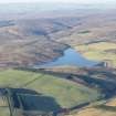
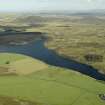
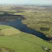
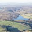
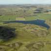
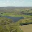
Watch Water Reservoir


Dam (Period Unassigned), Reservoir (Period Unassigned)
Site Name Watch Water Reservoir
Classification Dam (Period Unassigned), Reservoir (Period Unassigned)
Alternative Name(s) Scarlaw
Canmore ID 291942
Site Number NT65NE 49
NGR NT 66192 56443
Datum OSGB36 - NGR
Permalink http://canmore.org.uk/site/291942


- Council Scottish Borders, The
- Parish Longformacus
- Former Region Borders
- Former District Berwickshire
- Former County Berwickshire
NT65NE 49 66192 56443
Watch Water Reservoir [NAT]
OS 1:10,000 map, 1982.
For apparently-associated Longformacus Waterworks (centred NT 67768 56377), see NT65NE 53.
Watch Water Reservoir is situated in the valley of the Watch Water immediately E of Scarlaw farmstead and NE of Scarlaw Wood.
The reservoir has been formed by an earthen dam, overflow and sluice across the the Watch Water at NT 66257 56717.
The reservoir has been constructed since the Revision edition of the OS 25-inch (Berwickshire, 1907-1908, sheet xv)
Information from RCAHMS (DE), December 2007.

