
Wester Drumatherty


Linear Feature (Period Unknown)
Site Name Wester Drumatherty
Classification Linear Feature (Period Unknown)
Canmore ID 28992
Site Number NO14SW 66
NGR NO 114 411
NGR Description From NO 114 411 to NO 106 415
Datum OSGB36 - NGR
Permalink http://canmore.org.uk/site/28992
Ordnance Survey licence number AC0000807262. All rights reserved.
Canmore Disclaimer.
© Copyright and database right 2024.
- Correction
- Favourite

DP 052897
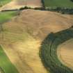
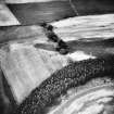
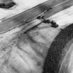
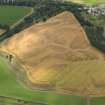
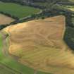
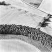
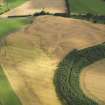
Oblique aerial view of the cropmarks of the quarry pits along the line of the Roman Road and the souterrains and unenclosed round houses at Wester Drumatherty, taken from the NNW.
RCAHMS Aerial Photography Digital
4/8/2008
© Crown Copyright: HES


SC 1710041
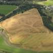
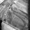
Spittalfield and Wester Drumatherty, oblique aerial view, taken from the ENE, centred on the cropmarks of a Roman road and quarry pits, a linear cropmark, a palisaded enclosure, a possible pit-alignment, a round house and souterrains.
RCAHMS Aerial Photography
15/8/1996
© Crown Copyright: HES

SC 1710042
Spittalfield and Wester Drumatherty, oblique aerial view, taken from the NE, centred on the cropmarks of a Roman road and quarry pits, a linear cropmark, a palisaded enclosure, a possible pit-alignment, a round house and souterrains.
RCAHMS Aerial Photography
15/8/1996
© Crown Copyright: HES

SC 1710052
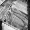
Oblique aerial view centred on the cropmarks of the palisaded enclosure, ring-ditch, Roman road, round house, souterrain, pits, linear cropmark and possible pit-alignment, taken from the WNW.
RCAHMS Aerial Photography
31/7/2001
© Crown Copyright: HES


SC 1710164
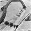
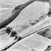
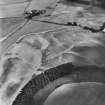
Wester Drumatherty, oblique aerial view, taken from the N, centred on the cropmarks of a Roman road and quarry pits, a linear cropmark and an unenclosed settlement.
RCAHMS Aerial Photography
15/8/1996
© Crown Copyright: HES

SC 1710168
Oblique aerial view centred on the cropmarks of the quarry pits flanking a Roman Road with linear cropmarks and unenclosed settlement adjacent, taken from the NW.
RCAHMS Aerial Photography
6/7/1998
© Crown Copyright: HES

SC 1710170
Oblique aerial view centred on the cropmarks of the quarry pits flanking a Roman Road with linear cropmarks and unenclosed settlement adjacent, taken from the SW.
RCAHMS Aerial Photography
6/7/1998
© Crown Copyright: HES


SC 2398638
Wester Drumatherty, NO14SW 66, Ordnance Survey index card, page number 3, Recto
Records of the Ordnance Survey, Southampton, Hampshire, England
1958
© Crown Copyright: HES (Ordnance Survey Archaeology Division Collection)


SC 623992
Spittalfield and Wester Drumatherty, oblique aerial view, taken from the ENE, centred on the cropmarks of a Roman road and quarry pits, a linear cropmark, a palisaded enclosure, a possible pit-alignment, a round house and souterrains.
RCAHMS Aerial Photography
15/8/1996
© Crown Copyright: HES

DP 052899
Oblique aerial view of the cropmarks of the quarry pits along the line of the Roman Road and the souterrains and unenclosed round houses at Wester Drumatherty, taken from the NW.
RCAHMS Aerial Photography Digital
4/8/2008
© Crown Copyright: HES


SC 1710054
Oblique aerial view centred on the cropmarks of the palisaded enclosure, ring-ditch, Roman road, round house, souterrain, pits, linear cropmark and possible pit-alignment, taken from the WSW.
RCAHMS Aerial Photography
31/7/2001
© Crown Copyright: HES


SC 2398641
Wester Drumatherty, NO14SW 66, Ordnance Survey index card, Recto
Records of the Ordnance Survey, Southampton, Hampshire, England
1958
© Crown Copyright: HES (Ordnance Survey Archaeology Division Collection)

DP 052895
Oblique aerial view of the cropmarks of the quarry pits along the line of the Roman Road and the souterrains and unenclosed round houses at Wester Drumatherty, taken from the N.
RCAHMS Aerial Photography Digital
4/8/2008
© Crown Copyright: HES


SC 1710048
Oblique aerial view centred on the cropmarks of the palisaded enclosure, ring-ditch, Roman road, round house, souterrain, pits, linear cropmark and possible pit-alignment, taken from the E.
RCAHMS Aerial Photography
31/7/2001
© Crown Copyright: HES


SC 1710158
Wester Drumatherty, oblique aerial view, taken from the SSW, centred on the cropmarks of a Roman road and quarry pits, and a linear cropmark. An unenclosed settlement is visible in the right half of the photograph.
RCAHMS Aerial Photography
28/8/1995
© Crown Copyright: HES

SC 1710159
Wester Drumatherty, oblique aerial view, taken from the SSE, centred on the cropmarks of a Roman road and quarry pits, and a linear cropmark. An unenclosed settlement is visible in the right half of the photograph.
RCAHMS Aerial Photography
28/8/1995
© Crown Copyright: HES

SC 1710163
Wester Drumatherty, oblique aerial view, taken from the E, centred on the cropmarks of a Roman Road and unenclosed settlement.
RCAHMS Aerial Photography
24/7/1996
© Crown Copyright: HES

SC 1710165
Wester Drumatherty, oblique aerial view, taken from the NW, centred on the cropmarks of a Roman road and quarry pits, a linear cropmark and an unenclosed settlement.
RCAHMS Aerial Photography
15/8/1996
© Crown Copyright: HES

SC 1710166
Wester Drumatherty, oblique aerial view, taken from the SW, centred on the cropmarks of a Roman road and quarry pits, a linear cropmark and an unenclosed settlement.
RCAHMS Aerial Photography
15/8/1996
© Crown Copyright: HES

SC 1710167
Wester Drumatherty, oblique aerial view, taken from the SW, centred on the cropmarks of a Roman road and quarry pits, a linear cropmark and an unenclosed settlement.
RCAHMS Aerial Photography
15/8/1996
© Crown Copyright: HES

SC 1710169
Oblique aerial view centred on the cropmarks of the quarry pits flanking a Roman Road with linear cropmarks and unenclosed settlement adjacent, taken from the WSW.
RCAHMS Aerial Photography
6/7/1998
© Crown Copyright: HES

SC 1710184
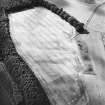
Oblique aerial view centred on the cropmarks of the Roman road, taken from the ESE.
RCAHMS Aerial Photography
31/7/2001
© Crown Copyright: HES


SC 505320
Wester Drumatherty, oblique aerial view, taken from the NW, centred on the cropmarks of a Roman road and quarry pits, a linear cropmark and an unenclosed settlement.
© RCAHMS


SC 1710049
General oblique aerial view centred on the cropmarks of the palisaded enclosure, ring-ditch, linear cropmark and Roman road, taken from the ENE.
RCAHMS Aerial Photography
31/7/2001
© Crown Copyright: HES

SC 1710053
Oblique aerial view centred on the cropmarks of the palisaded enclosure, ring-ditch, Roman road, round house, souterrain, pits, linear cropmark and possible pit-alignment, taken from the W.
RCAHMS Aerial Photography
31/7/2001
© Crown Copyright: HES

SC 1710055
Oblique aerial view centred on the cropmarks of the palisaded enclosure, ring-ditch, Roman road, round house, souterrain, pits, linear cropmark and possible pit-alignment, taken from the ENE.
RCAHMS Aerial Photography
31/7/2001
© Crown Copyright: HES


SC 1710156
Wester Drumatherty, oblique aerial view, taken from the NW, centred on the cropmarks of a Roman road and quarry pits, a linear cropmark and an unenclosed settlement.
RCAHMS Aerial Photography
28/8/1995
© Crown Copyright: HES

SC 2398639
Wester Drumatherty, NO14SW 66, Ordnance Survey index card, Recto
Records of the Ordnance Survey, Southampton, Hampshire, England
1958
© Crown Copyright: HES (Ordnance Survey Archaeology Division Collection)

DP 052893
Oblique aerial view of the cropmarks of the quarry pits along the line of the Roman Road and the souterrains and unenclosed round houses at Wester Drumatherty, taken from the N.
RCAHMS Aerial Photography Digital
4/8/2008
© Crown Copyright: HES

DP 052896
Oblique aerial view of the cropmarks of the quarry pits along the line of the Roman Road and the souterrains and unenclosed round houses at Wester Drumatherty, taken from the NNW.
RCAHMS Aerial Photography Digital
4/8/2008
© Crown Copyright: HES


SC 1710039
Spittalfield and Wester Drumatherty, oblique aerial view, taken from the SE, centred on the cropmarks of a Roman road and quarry pits, a linear cropmark, a palisaded enclosure, a possible pit-alignment, a round house and souterrains.
RCAHMS Aerial Photography
15/8/1996
© Crown Copyright: HES


SC 1710161
Wester Drumatherty, oblique aerial view, taken from the ESE, centred on the cropmarks of a Roman Road and unenclosed settlement.
RCAHMS Aerial Photography
24/7/1996
© Crown Copyright: HES

SC 1710185
Oblique aerial view centred on the cropmarks of the Roman road, taken from the ESE.
RCAHMS Aerial Photography
31/7/2001
© Crown Copyright: HES


SC 2398634
Wester Drumatherty, NO14SW 66, Ordnance Survey index card, Recto
Records of the Ordnance Survey, Southampton, Hampshire, England
1958
© Crown Copyright: HES (Ordnance Survey Archaeology Division Collection)

SC 2398635
Wester Drumatherty, NO14SW 66, Ordnance Survey index card, Recto
Records of the Ordnance Survey, Southampton, Hampshire, England
1958
© Crown Copyright: HES (Ordnance Survey Archaeology Division Collection)

SC 2398636
Wester Drumatherty, NO14SW 66, Ordnance Survey index card, page number 1, Recto
Records of the Ordnance Survey, Southampton, Hampshire, England
1958
© Crown Copyright: HES (Ordnance Survey Archaeology Division Collection)

SC 2398640
Wester Drumatherty, NO14SW 66, Ordnance Survey index card, Recto
Records of the Ordnance Survey, Southampton, Hampshire, England
1958
© Crown Copyright: HES (Ordnance Survey Archaeology Division Collection)

DP 052898
Oblique aerial view of the cropmarks of the quarry pits along the line of the Roman Road and the souterrains and unenclosed round houses at Wester Drumatherty, taken from the NNW.
RCAHMS Aerial Photography Digital
4/8/2008
© Crown Copyright: HES

SC 1710050
Oblique aerial view centred on the cropmarks of the palisaded enclosure, ring-ditch, Roman road, round house, souterrain, pits, linear cropmark and possible pit-alignment, taken from the N.
RCAHMS Aerial Photography
31/7/2001
© Crown Copyright: HES


SC 1710188
Oblique aerial view centred on the cropmarks of the Roman road, taken from the N.
RCAHMS Aerial Photography
31/7/2001
© Crown Copyright: HES


SC 1710040
Spittalfield and Wester Drumatherty, oblique aerial view, taken from the ESE, centred on the cropmarks of a Roman road and quarry pits, a linear cropmark, a palisaded enclosure, a possible pit-alignment, a round house and souterrains.
RCAHMS Aerial Photography
15/8/1996
© Crown Copyright: HES

SC 1710047
Oblique aerial view centred on the cropmarks of the palisaded enclosure, ring-ditch, Roman road, round house, souterrain, pits, linear cropmark and possible pit-alignment, taken from the ESE.
RCAHMS Aerial Photography
31/7/2001
© Crown Copyright: HES

SC 1710051
Oblique aerial view centred on the cropmarks of the palisaded enclosure, ring-ditch, Roman road, round house, souterrain, pits, linear cropmark and possible pit-alignment, taken from the NW.
RCAHMS Aerial Photography
31/7/2001
© Crown Copyright: HES


SC 1710157
Wester Drumatherty, oblique aerial view, taken from the WNW, centred on the cropmarks of a Roman road and quarry pits, a linear cropmark and an unenclosed settlement.
RCAHMS Aerial Photography
28/8/1995
© Crown Copyright: HES

SC 1710160
Wester Drumatherty, oblique aerial view, taken from the ESE, centred on the cropmarks of a Roman road and quarry pits, a linear cropmark and an unenclosed settlement.
RCAHMS Aerial Photography
28/8/1995
© Crown Copyright: HES

SC 1710162
Wester Drumatherty, oblique aerial view, taken from the SE, centred on the cropmarks of a Roman Road and unenclosed settlement.
RCAHMS Aerial Photography
24/7/1996
© Crown Copyright: HES

SC 1710187
Oblique aerial view centred on the cropmarks of the Roman road, taken from the NW.
RCAHMS Aerial Photography
31/7/2001
© Crown Copyright: HES

SC 2398642
Wester Drumatherty, NO14SW 66, Ordnance Survey index card, Recto
Records of the Ordnance Survey, Southampton, Hampshire, England
1958
© Crown Copyright: HES (Ordnance Survey Archaeology Division Collection)


SC 1710186
Oblique aerial view centred on the cropmarks of the Roman road, taken from the E.
RCAHMS Aerial Photography
31/7/2001
© Crown Copyright: HES

SC 2398637
Wester Drumatherty, NO14SW 66, Ordnance Survey index card, page number 2, Recto
Records of the Ordnance Survey, Southampton, Hampshire, England
1958
© Crown Copyright: HES (Ordnance Survey Archaeology Division Collection)


- Council Perth And Kinross
- Parish Caputh
- Former Region Tayside
- Former District Perth And Kinross
- Former County Perthshire
NO14SW 66 from 114 411 to 106 415
See also NO14SW 30.
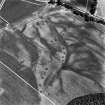
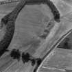
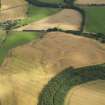
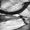
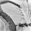
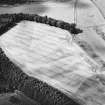
Air reconnaissance has revealed, in addition to the roads and quarry-pits noted on NO14SW 30, a narrow linear cropmark running from the scarp at Redgole Bank towards the point where the road divided, and then continuing beside the western fork. Sections dug in 1983-4 showed this to be a flat-bottomed channel or ditch, 1.07m wide at the top and 0.84m deep, in maximum dimensions. The feature was traced for nearly 1000m across gently-undulating ground towards the NW end of the plateau. That this was an unfinished trench dug to hold a line of wooden pipes conveying water from the upper reaches of the Millhole Burn as a temporary limited provision for Inchtuthil fortress (NO13NW 5) is an interesting conjecture, which remains unproven.
L F Pitts and J K St Joseph 1985
Excavation (1993)
A linear cropmark flanking the Roman road at Wester Drumatherty was sectioned in 1983 and 1984. The feature was seen to be a channel of U-profile, about 1m wide at the lips and not more that 0.85m deep. It has been suggested (by Pitts and St Joseph) that it may have been intended to hold wooden pipes conveying water to the fortress at Inchtuthil, as part of a temporary and limited provision in the early days of construction. The right-hand branch of the road (see NO14SW 30) appears to overlie the channel at one point.
Information from RCAHMS (GSM) December 1993.
L F Pitts and J K St Joseph 1985; G S Mxwell and D R Wilson 1987.

