 |
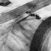
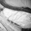
On-line Digital Images |
SC 1710147 |
RCAHMS Aerial Photography |
Oblique aerial view. |
1992 |
Item Level |
|
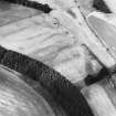 |
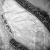
On-line Digital Images |
SC 1710148 |
RCAHMS Aerial Photography |
Oblique aerial view. |
1992 |
Item Level |
|
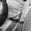 |
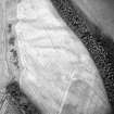
On-line Digital Images |
SC 1710149 |
RCAHMS Aerial Photography |
Oblique aerial view. |
1992 |
Item Level |
|
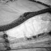 |
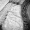
On-line Digital Images |
SC 1710179 |
RCAHMS Aerial Photography |
Oblique aerial view of Spittalfield centred on the cropmarks of a round house and souterrain with Roman road adjacent, taken from the N. |
22/7/1999 |
Item Level |
|
 |
On-line Digital Images |
SC 1710180 |
RCAHMS Aerial Photography |
Oblique aerial view of Spittalfield centred on the cropmarks of a round house and souterrain with Roman road adjacent, taken from the NW. |
22/7/1999 |
Item Level |
|
 |
On-line Digital Images |
SC 1710181 |
RCAHMS Aerial Photography |
Oblique aerial view of Spittalfield centred on the cropmarks of a round house and souterrain with Roman road adjacent, taken from the NW. |
22/7/1999 |
Item Level |
|
 |
On-line Digital Images |
SC 1710182 |
RCAHMS Aerial Photography |
Oblique aerial view of Spittalfield centred on the cropmarks of a round house and souterrain with Roman road adjacent, taken from the W. |
22/7/1999 |
Item Level |
|
 |
On-line Digital Images |
SC 1710183 |
RCAHMS Aerial Photography |
Oblique aerial view of Spittalfield centred on the cropmarks of a round house and souterrain with Roman road adjacent, taken from the WSW. |
22/7/1999 |
Item Level |
|
|
Photographs and Off-line Digital Images |
SC 1925384 |
Cambridge University Collection for Aerial Photography |
Oblique aerial view |
19/7/1961 |
Item Level |
|
|
Photographs and Off-line Digital Images |
SC 1931285 |
Cambridge University Collection for Aerial Photography |
Oblique aerial view of Spittalfield, palisaded enclosure and Wester Drumatherty, Roman road: Dunkeld.
|
20/7/1977 |
Item Level |
|
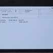 |
On-line Digital Images |
SC 2398632 |
Records of the Ordnance Survey, Southampton, Hampshire, England |
Spittalfield, NO14SW 65, Ordnance Survey index card, Recto |
1958 |
Item Level |
|
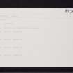 |
On-line Digital Images |
SC 2398633 |
Records of the Ordnance Survey, Southampton, Hampshire, England |
Spittalfield, NO14SW 65, Ordnance Survey index card, Recto |
1958 |
Item Level |
|


