|
Photographs and Off-line Digital Images |
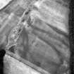
A 30132 |
RCAHMS Aerial Photography |
Oblique aerial view. |
1986 |
Item Level |
|
|
Photographs and Off-line Digital Images |
A 30133 |
RCAHMS Aerial Photography |
Oblique aerial view. |
1986 |
Item Level |
|
|
All Other |
A 30134 TR |
RCAHMS Aerial Transcription |
Transcription. Composite of A30134 DIG and PT11019 DIG; also covers NO14SW 30, 65 and 72 |
1989 |
Item Level |
|
|
Photographs and Off-line Digital Images |
A 30135 |
RCAHMS Aerial Photography |
Oblique aerial view. |
1986 |
Item Level |
|
|
Photographs and Off-line Digital Images |
A 35130 PO |
Cambridge University Collection for Aerial Photography |
Oblique aerial view of Spittalfield, palisaded enclosure and Wester Drumatherty, Roman road: Dunkeld.
|
20/7/1977 |
Item Level |
|
|
Manuscripts |
MS 840/67 |
RCAHMS Aerial Transcription |
Transcription file |
1989 |
Item Level |
|
|
Photographs and Off-line Digital Images |
PT 11019 PO |
Cambridge University Collection for Aerial Photography |
Oblique aerial view |
19/7/1961 |
Item Level |
|
|
Photographs and Off-line Digital Images |
C 1364 |
RCAHMS Aerial Photography |
Oblique aerial view. |
1992 |
Item Level |
|
|
Photographs and Off-line Digital Images |
C 1367 |
RCAHMS Aerial Photography |
Oblique aerial view. |
1992 |
Item Level |
|
|
Photographs and Off-line Digital Images |
C 1366 |
RCAHMS Aerial Photography |
Oblique aerial view. |
1992 |
Item Level |
|
|
Photographs and Off-line Digital Images |
C 1365 |
RCAHMS Aerial Photography |
Oblique aerial view. |
1992 |
Item Level |
|
|
Photographs and Off-line Digital Images |
A 30134 |
RCAHMS Aerial Photography |
Oblique aerial view. |
1986 |
Item Level |
|
 |
On-line Digital Images |
SC 397562 |
|
|
|
Item Level |
|
|
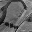
Photographs and Off-line Digital Images |
C 76085 |
RCAHMS Aerial Photography |
Spittalfield and Wester Drumatherty, oblique aerial view, taken from the NE, centred on the cropmarks of a Roman road and quarry pits, a linear cropmark, a palisaded enclosure, a possible pit-alignment, a round house and souterrains. |
15/8/1996 |
Item Level |
|
|
Photographs and Off-line Digital Images |
C 76084 |
RCAHMS Aerial Photography |
Spittalfield and Wester Drumatherty, oblique aerial view, taken from the ENE, centred on the cropmarks of a Roman road and quarry pits, a linear cropmark, a palisaded enclosure, a possible pit-alignment, a round house and souterrains. |
15/8/1996 |
Item Level |
|
|
Photographs and Off-line Digital Images |
C 76083 |
RCAHMS Aerial Photography |
Spittalfield and Wester Drumatherty, oblique aerial view, taken from the ESE, centred on the cropmarks of a Roman road and quarry pits, a linear cropmark, a palisaded enclosure, a possible pit-alignment, a round house and souterrains. |
15/8/1996 |
Item Level |
|
|
Photographs and Off-line Digital Images |
C 76082 |
RCAHMS Aerial Photography |
Spittalfield and Wester Drumatherty, oblique aerial view, taken from the SE, centred on the cropmarks of a Roman road and quarry pits, a linear cropmark, a palisaded enclosure, a possible pit-alignment, a round house and souterrains. |
15/8/1996 |
Item Level |
|
 |
On-line Digital Images |
SC 623992 |
RCAHMS Aerial Photography |
Spittalfield and Wester Drumatherty, oblique aerial view, taken from the ENE, centred on the cropmarks of a Roman road and quarry pits, a linear cropmark, a palisaded enclosure, a possible pit-alignment, a round house and souterrains. |
15/8/1996 |
Item Level |
|
|
Photographs and Off-line Digital Images |
D 57111 |
RCAHMS Aerial Photography |
Oblique aerial view of Spittalfield centred on the cropmarks of a round house and souterrain with Roman road adjacent, taken from the N. |
22/7/1999 |
Item Level |
|
|
Photographs and Off-line Digital Images |
D 57112 |
RCAHMS Aerial Photography |
Oblique aerial view of Spittalfield centred on the cropmarks of a round house and souterrain with Roman road adjacent, taken from the NW. |
22/7/1999 |
Item Level |
|
|
Photographs and Off-line Digital Images |
D 57113 |
RCAHMS Aerial Photography |
Oblique aerial view of Spittalfield centred on the cropmarks of a round house and souterrain with Roman road adjacent, taken from the NW. |
22/7/1999 |
Item Level |
|
|
Photographs and Off-line Digital Images |
D 57114 |
RCAHMS Aerial Photography |
Oblique aerial view of Spittalfield centred on the cropmarks of a round house and souterrain with Roman road adjacent, taken from the W. |
22/7/1999 |
Item Level |
|
|
Photographs and Off-line Digital Images |
D 57115 |
RCAHMS Aerial Photography |
Oblique aerial view of Spittalfield centred on the cropmarks of a round house and souterrain with Roman road adjacent, taken from the WSW. |
22/7/1999 |
Item Level |
|
|
Photographs and Off-line Digital Images |
E 11063 |
RCAHMS Aerial Photography |
Oblique aerial view centred on the cropmarks of the palisaded enclosure, ring-ditch, Roman road, round house, souterrain, pits, linear cropmark and possible pit-alignment, taken from the ESE. |
31/7/2001 |
Item Level |
|


