|
Photographs and Off-line Digital Images |
E 11077 |
RCAHMS Aerial Photography |
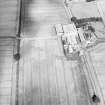
Oblique aerial view centred on the farmhouse and farmsteading, taken from the WSW. |
31/7/2001 |
Item Level |
|
|
Photographs and Off-line Digital Images |
E 11078 |
RCAHMS Aerial Photography |
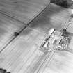
Oblique aerial view centred on the farmhouse and farmsteading, taken from the SSW. |
31/7/2001 |
Item Level |
|
 |
On-line Digital Images |
SC 1710189 |
RCAHMS Aerial Photography |
Oblique aerial view centred on the farmhouse and farmsteading, taken from the WSW. |
31/7/2001 |
Item Level |
|
 |
On-line Digital Images |
SC 1710190 |
RCAHMS Aerial Photography |
Oblique aerial view centred on the farmhouse and farmsteading, taken from the SSW. |
31/7/2001 |
Item Level |
|
 |
On-line Digital Images |
SC 2398614 |
Records of the Ordnance Survey, Southampton, Hampshire, England |
Middle Gourdie, Steading, NO14SW 52.1, Ordnance Survey index card, Recto |
1958 |
Item Level |
|


