
Clunie, Castle Hill


Castle (Medieval), Earthwork (Period Unknown)(Possible)
Site Name Clunie, Castle Hill
Classification Castle (Medieval), Earthwork (Period Unknown)(Possible)
Alternative Name(s) Castle Hill, Clunie; Clunie Castle; Clunie Motte
Canmore ID 28970
Site Number NO14SW 5
NGR NO 11075 44030
NGR Description Centred NO 11075 44030
Datum OSGB36 - NGR
Permalink http://canmore.org.uk/site/28970


- Council Perth And Kinross
- Parish Clunie
- Former Region Tayside
- Former District Perth And Kinross
- Former County Perthshire
NO14SW 5 Centred on NO 11075 44030
(NO 1107 4403) Castle Hill (NR)
(NO 1108 4399) Castle (NR) (Site of)
OS 6" map, Perthshire (1959)
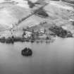
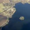
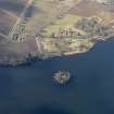
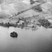
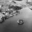
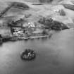
For Clunie Castle (on Island of Clunie), see NO14SW 4.
A castle said to have been the summer palace of King Kenneth McAlpin in the 9th c stood on Castle Hill. The site would appear to have been a stronghold of some importance as it was occupied by Edward I in 1296, when a castle of the 1st Period (1200-1300) was erected.
D MacGibbon and T Ross 1889
Remains of this building are visible, comprising a mortared stone wall on the S end of the hill and a stone and earthen bank round the top. The slopes are covered with strip lynchets.
Information from O G S Crawford 17 May 1943
A Norman motte and bailey.
Information from M E C Stewart 2 February 1956
Field Visit (14 November 1975)
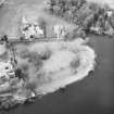
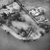
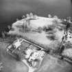
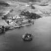
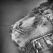
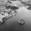
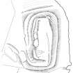
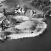
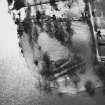
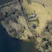
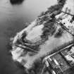
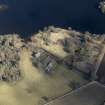
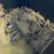
Occupying the level summit of Castle Hill (name verified), a natural knoll under pasture, are the tenuous remains of a stone-built castle. The main castle building is situated at the S extremity of the summit; the remains comprise five separate blocks of mortared wall core up to 2.0m high. No architectural features survive and the plan of the structure is uncertain; it appears to have been largely quarried away. Its position guarding an obvious entrance causeway up the S slopes of the hill suggests an enlarged gatehouse. Extending from the NW corner of the castle along the W edge of the summit are the turf-covered footings of a curtain wall, partly destroyed by quarrying. There is no evidence of it on the N and E sides. The summit measures circa 90.0m N-S by 40.0m; apart from the aforementioned castle, no other structure survives in the enclosed area though rank grass and nettle growth suggests buried foundations.
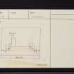
The castle has been further defended by a series of terraces cut into the side of the hill (see section). The lowest terrace on the N side may have been for cultivation as it is wider than the others, it does not form a cohesive part of the outer defences, and it is parallel with rig-and-furrow to the N at the base of the hill.
The building remains are indicative of a 13th c castle of enceinte. It was probably constructed on an earlier motte.
Resurveyed at 1:2500.
Visited by OS (NKB) 14 November 1975
Field Visit (17 May 1989)
On the summit of Castle Hill, Clunie, there are the remains of a royal castle, which was probably a hunting lodge for the forest of Clunie. These comprise fragments of the wall-core of what has been probably quite a large building situated on the S side of the summit and possibly traces of a heavily-robbed and quarried curtain wall. Access to the castle was by means of a terraced trackway on the S. The sides of the hill are also terraced and, while some of these may be due to later landscaping or agricultural activity, it is possible that at least one is defensive in nature.
Clunie in Stormont, is on record in 849, and the royal seat from about 1141; in 1296 it was occupied by Edward I. Stone from the castle was used for the tower-house on the island in Lock of Clunie (NO14SW 4) and, in 1513, four men were employed for a year to clear the remaining rubble from the summit. The evidence for quarrying perhaps dates from this period.
Visited by RCAHMS (IMS) 17 May 1989.
Statistical Account (OSA); Dunkeld Rentale; MacGibbon and Ross 1889; A C Lawrie 1905; A O Anderson 1922; Reg Reg Scot; L Alcock 1981.
Measured Survey (1989)
RCAHMS surveyed Clunie, Castle Hill earthwork (NO14SW 5) with plane-table and self-reducing alidade in 1989 at a scale of 1:500. The resultant plan was redrawn in ink and published at a scale of 1:1000 (RCAHMS 1994b, 105(A)).
Note (11 May 2015 - 18 May 2016)
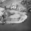
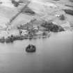
Clunie Castle occupies a natural hillock known as Castle Hill between Clunie parish church and the W shore of the Loch of Clunie. The castle is known to have been established in 1141 as a hunting seat for the royal forest of Clunie on the hills to the N, but documentary sources have led to the suggestion that there was a fortified site at Cluny from at least AD 849 (Alcock 1981, 161), and the hillock may well have been adapted as a motte before the remains of the stone castle visible on its summit was built. The latter comprise fragments of a building at the SW angle of the rectangular summit of hillock, and lengths of probable curtain wall on the E and the NW. The summit itself measures about 90m from NNW to SSE by up to 40m transversely (0.35ha) and its margins are sharply scarped, falling away steeply on the S, E and N to an artificial terrace which can also be traced round onto the W. Here, however, there is also an intermediate terrace above it and an outer terrace below it, giving the impression of a set of garden terraces. Without excavation it is impossible to unravel the history of these various elements, to distinguish any later landscaping from the defences of the stone castle and any earth and timber predecessor, let alone any early medieval fortification that may have occupied the same site. The stone castle was demolished in the early sixteenth century to a build a tower-house for the Bishops of Dunkeld on an island in the loch.
Information from An Atlas of Hillforts of Great Britain and Ireland – 18 May 2016. Atlas of Hillforts SC3045
Project (10 December 2018 - 5 February 2019)
NO 11075 44030 Clunie is mentioned in 849 AD in ‘The Chronicle of the Kings of Alba’, when the Danes are said to have ‘wasted’ Pictland as far as Clunie. From 1141 onwards, it is mentioned as a royal seat. Alexander II, King of the Scots, is recorded as residing in the castle in 1215, and in 1296, the site was occupied by Edward I. The lands around Clunie were also designated as a royal forest from the 12th century. There are also two important silver pennannular brooches that are said to have been found near Clunie Castle, which are likely Pictish in origin. There is also a concentration of significant later medieval material in the immediate environs of the hill. This includes two 13th century coins 200m to the south of the hill (NO14SW 83); a silver halfpenny of King John minted in 1205–1210 ‘near Lough Clunie’ (NO14SW 84); a copper-alloy pendant, copper-alloy brooch and copper-alloy of 13th/14th century date in the area immediately surrounding the hill (NO14SW 140); and a lead papal bulla of Pope Honorious III dating to 1216–1227 AD approximately 20m to the N of the site (NO14SW 85).
Work carried out 10-14 December 2018 and 4-5 February 2019 included geophysical survey on and around the hill in order to contextualize the above finds, and in an attempt to reveal any features that might be associated with the hill. An area of approximately 0.17ha, comprising the entire summit of Clunie Hill, and an area of 0.44ha at the northern and western base of the hill was surveyed with a Geoscan Research RM85 electrical resistance meter, while an area of around 5ha to the west of the scheduled area was surveyed with a Bartington 601-2 gradiometry system, with targeted resistance survey. These surveys revealed possible enclosing elements at the base of the hill on its northern and western side. Survey of the land to the east of the nearby church revealed a series of linear and curving anomalies which were tested by excavation.
Four small trenches were excavated across the line of each linear/curving feature. Three trenches revealed the anomalies to be post-medieval drains or disused pipes, while a fourth trench, measuring approximately 5m by 2m, revealed two shallow pits and a spread of dark humic soil. None of these features produced datable material.
Archive: University of Aberdeen
Funder: University of Aberdeen
James O’Driscoll and Gordon Noble - University of Aberdeen
(Source: DES Vol 20)
Resistivity (10 December 2018 - 5 February 2019)
NO 11075 44030 Resistivity survey.
Archive: University of Aberdeen
Funder: University of Aberdeen
James O’Driscoll and Gordon Noble - University of Aberdeen
(Source: DES Vol 20)
Magnetometry (10 December 2018 - 5 February 2019)
NO 11075 44030 Magnetometry survey.
Archive: University of Aberdeen
Funder: University of Aberdeen
James O’Driscoll and Gordon Noble - University of Aberdeen
(Source: DES Vol 20)

