
Wester Drumatherty


Roman Road (Roman)
Site Name Wester Drumatherty
Classification Roman Road (Roman)
Alternative Name(s) Spittalfield; Millhole Burn
Canmore ID 28949
Site Number NO14SW 30
NGR NO 1075 4156
NGR Description NO 1075 4156 to NO 1151 4097
Datum OSGB36 - NGR
Permalink http://canmore.org.uk/site/28949


First 100 images shown. See the Collections panel (below) for a link to all digital images.
- Council Perth And Kinross
- Parish Caputh
- Former Region Tayside
- Former District Perth And Kinross
- Former County Perthshire
Field Visit (1982)
NO14SW 30 From 1075 4156 to 1151 4097
See also NO14SW 20.
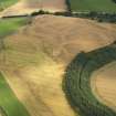
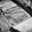
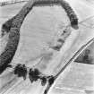
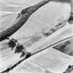
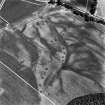
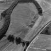
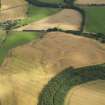
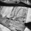
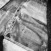
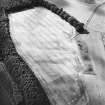
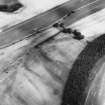
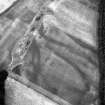
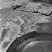
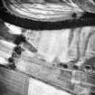
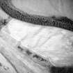
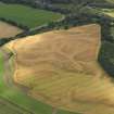
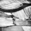
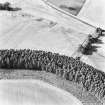
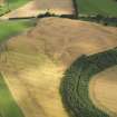
Immediately to the W of the homestead and settlement (NO 14 SW 20) a complex pattern of cropmarks indicates the position of a sector of the Roman road leading from the legionary fortress at Inchtuthil to the stone-quarries on the Hill of Gourdie. Ground observation revealed an agger c. 10m wide pointing towards a cutting due S of Middle Gourdie farm, but cropmarks also indicate a branch heading NW, about 550m N of Spittalfield village.
G S Maxwell 1982
Excavation (1983)
Further investigation revealed that the cambered agger of the main N- S alignment was reasonably well preserved beneath an old field-boundary; its width was c. 8.3m and it consisted of layers of sandy soil, gravel and stones, surviving to a height of 0.3m above the old topsoil. A section through the branch leading to the NW indicated a similar width and style of construction, but the agger was only 0.2m high; on the NE of this branch, and some 7m distant from it, there lay a side-ditch, about 1.0m wide and 0.5m deep. A similar ditch may be detected as a cropmark on the E side of the N-S alignment to the S of the road junction, but excavation confirmed that it had not originally been continuous.
G S Maxwell and J K St Joseph 1983
Excavation (1984)
Further investigation revealed a little more about the course and nature of a channel about 1.0m wide and 1.0m deep. It now seems less likely that it served as a roadside ditch or as a water channel; at one point, where air photographs suggested that it changed alignment slightly, excavation revealed that it crossed an earlier sub- rectangular depression, apparently the site of a house, with trodden earth floor. No artefacts were recovered from the latter surface, but a core of brown chert was recovered from the field-surface in its immediate vicinity.
G S Maxwell and J K St Joseph 1984
Excavation (1987)
The Roman presence was represented by traces of a well-built metalled road, which forked in the middle of its course across the plateau, one branch proceeding northwards in the direction of the stone-quarry on Gourdie Hill, from which it is conjectured that the material for the fortress wall was won. It is not known whether the other branch, which continued in a northwesterly direction towards the far edge of the plateau, was merely providing an alternative route to the quarry involving more gentle gradients, or proceeding to some outlying post, situated nearer the narrows of the Dunkeld gap. Excavation failed to disclose the purpose of the narrow channel which ran alongside this branch as well as the main trunk of the road; it was clearly not a drainage ditch, and its identification as the rough-out for an aqueduct feeding the fortress remains unproven.
G S Maxwell and D R Wilson 1987
Aerial Photographic Transcription (16 January 1990)
An aerial transcription was produced from oblique aerial photographs. Information from Historic Environment Scotland (BM) 31 March 2017.
Aerial Photographic Interpretation (7 December 1992)
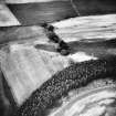
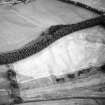
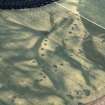
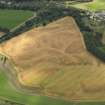
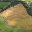
A short sector of Roman road traversing the gravel plateau to the W of Wester Drumatherty has been revealed by cropmarks recorded during aerial survey. A northward continuation of the road that issues from the NW gate of the legionary fortress of Inchtuthil, it ascends Redgole Bank, the S scarp of the plateau, by a much-eroded causeway and cutting (NO 1151 4097), now obscured by tipping and thickly overgrown with vegetation. Its course across the cultivated fields on the plateau summit at first points directly at the presumed Roman sandstone-quarry on Hill of Gourdie (NO14SW 33) and in this sector it is intermittently visible as a low bank 5m in average width, although both here and elsewhere the parched corn above road-metalling and the cropmarks of roadside quarry-pits indicate its track more clearly. About 200m NNW of the S plateau-scarp the road bifurcates, one branch bending a little to the N and continuing another 260m to the NE, towards a broad cutting in the NE scarp, where the road descends to a crossing of the Millhole Burn; beyond this no traces have been recorded. The second branch inclines to the NW and quarry-pits indicate its course for about 500m before it too reaches the N scarp of the plateau; no further traces of this branch have been observed but a modern farm-road continues the alignment in the direction of Millhole farm.
Excavation in 1983 demonstrated that the road had been robustly-built, with a rammed-gravel metalling resting on a bottoming of large river-cobbles and an agger of compacted earth and turf 6m wide.
Information from RCAHMS (JRS) 7 December 1992.
G S Maxwell and J K St Joseph 1983.

