 |
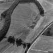
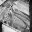
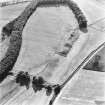
On-line Digital Images |
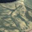
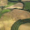
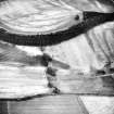
SC 359710 |
RCAHMS Aerial Photography |
Oblique aerial view. |
1982 |
Item Level |
|
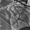 |
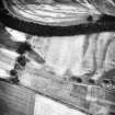
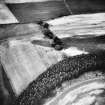
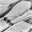
On-line Digital Images |
SC 393692 |
RCAHMS Aerial Photography |
Oblique aerial view. |
1982 |
Item Level |
|
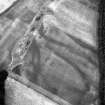 |
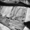
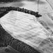
On-line Digital Images |
SC 397562 |
|
|
|
Item Level |
|
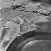 |
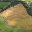
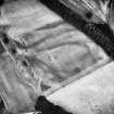
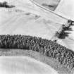
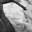
On-line Digital Images |
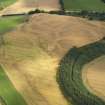
SC 505320 |
|
Wester Drumatherty, oblique aerial view, taken from the NW, centred on the cropmarks of a Roman road and quarry pits, a linear cropmark and an unenclosed settlement. |
|
Item Level |
|
 |
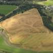
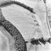
On-line Digital Images |
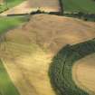
SC 623992 |
RCAHMS Aerial Photography |
Spittalfield and Wester Drumatherty, oblique aerial view, taken from the ENE, centred on the cropmarks of a Roman road and quarry pits, a linear cropmark, a palisaded enclosure, a possible pit-alignment, a round house and souterrains. |
15/8/1996 |
Item Level |
|
 |
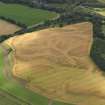
On-line Digital Images |
DP 052893 |
RCAHMS Aerial Photography Digital |
Oblique aerial view of the cropmarks of the quarry pits along the line of the Roman Road and the souterrains and unenclosed round houses at Wester Drumatherty, taken from the N. |
4/8/2008 |
Item Level |
|
 |
On-line Digital Images |
DP 052895 |
RCAHMS Aerial Photography Digital |
Oblique aerial view of the cropmarks of the quarry pits along the line of the Roman Road and the souterrains and unenclosed round houses at Wester Drumatherty, taken from the N. |
4/8/2008 |
Item Level |
|
 |
On-line Digital Images |
DP 052896 |
RCAHMS Aerial Photography Digital |
Oblique aerial view of the cropmarks of the quarry pits along the line of the Roman Road and the souterrains and unenclosed round houses at Wester Drumatherty, taken from the NNW. |
4/8/2008 |
Item Level |
|
 |
On-line Digital Images |
DP 052897 |
RCAHMS Aerial Photography Digital |
Oblique aerial view of the cropmarks of the quarry pits along the line of the Roman Road and the souterrains and unenclosed round houses at Wester Drumatherty, taken from the NNW. |
4/8/2008 |
Item Level |
|
 |
On-line Digital Images |
DP 052898 |
RCAHMS Aerial Photography Digital |
Oblique aerial view of the cropmarks of the quarry pits along the line of the Roman Road and the souterrains and unenclosed round houses at Wester Drumatherty, taken from the NNW. |
4/8/2008 |
Item Level |
|
 |
On-line Digital Images |
DP 052899 |
RCAHMS Aerial Photography Digital |
Oblique aerial view of the cropmarks of the quarry pits along the line of the Roman Road and the souterrains and unenclosed round houses at Wester Drumatherty, taken from the NW. |
4/8/2008 |
Item Level |
|
 |
On-line Digital Images |
SC 1709934 |
RCAHMS Aerial Photography |
Oblique aerial view. |
1986 |
Item Level |
|
 |
On-line Digital Images |
SC 1709935 |
RCAHMS Aerial Photography |
Oblique aerial view. |
1986 |
Item Level |
|
 |
On-line Digital Images |
SC 1709936 |
RCAHMS Aerial Photography |
Oblique aerial view. |
1986 |
Item Level |
|
 |
On-line Digital Images |
SC 1709937 |
RCAHMS Aerial Photography |
Oblique aerial view. |
1986 |
Item Level |
|
 |
On-line Digital Images |
SC 1709938 |
RCAHMS Aerial Photography |
Oblique aerial view. |
1986 |
Item Level |
|
 |
On-line Digital Images |
SC 1709939 |
RCAHMS Aerial Photography |
Oblique aerial view. |
1986 |
Item Level |
|
 |
On-line Digital Images |
SC 1709940 |
RCAHMS Aerial Photography |
Oblique aerial view. |
1986 |
Item Level |
|
 |
On-line Digital Images |
SC 1710039 |
RCAHMS Aerial Photography |
Spittalfield and Wester Drumatherty, oblique aerial view, taken from the SE, centred on the cropmarks of a Roman road and quarry pits, a linear cropmark, a palisaded enclosure, a possible pit-alignment, a round house and souterrains. |
15/8/1996 |
Item Level |
|
 |
On-line Digital Images |
SC 1710040 |
RCAHMS Aerial Photography |
Spittalfield and Wester Drumatherty, oblique aerial view, taken from the ESE, centred on the cropmarks of a Roman road and quarry pits, a linear cropmark, a palisaded enclosure, a possible pit-alignment, a round house and souterrains. |
15/8/1996 |
Item Level |
|
 |
On-line Digital Images |
SC 1710041 |
RCAHMS Aerial Photography |
Spittalfield and Wester Drumatherty, oblique aerial view, taken from the ENE, centred on the cropmarks of a Roman road and quarry pits, a linear cropmark, a palisaded enclosure, a possible pit-alignment, a round house and souterrains. |
15/8/1996 |
Item Level |
|
 |
On-line Digital Images |
SC 1710042 |
RCAHMS Aerial Photography |
Spittalfield and Wester Drumatherty, oblique aerial view, taken from the NE, centred on the cropmarks of a Roman road and quarry pits, a linear cropmark, a palisaded enclosure, a possible pit-alignment, a round house and souterrains. |
15/8/1996 |
Item Level |
|
 |
On-line Digital Images |
SC 1710047 |
RCAHMS Aerial Photography |
Oblique aerial view centred on the cropmarks of the palisaded enclosure, ring-ditch, Roman road, round house, souterrain, pits, linear cropmark and possible pit-alignment, taken from the ESE. |
31/7/2001 |
Item Level |
|
 |
On-line Digital Images |
SC 1710048 |
RCAHMS Aerial Photography |
Oblique aerial view centred on the cropmarks of the palisaded enclosure, ring-ditch, Roman road, round house, souterrain, pits, linear cropmark and possible pit-alignment, taken from the E. |
31/7/2001 |
Item Level |
|


