
Upper Largie


Quarry (20th Century)
Site Name Upper Largie
Classification Quarry (20th Century)
Canmore ID 287061
Site Number NR89NW 171
NGR NR 83251 99499
NGR Description Centre
Datum OSGB36 - NGR
Permalink http://canmore.org.uk/site/287061


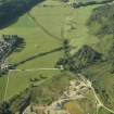
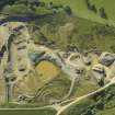

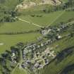
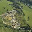
- Council Argyll And Bute
- Parish Kilmartin
- Former Region Strathclyde
- Former District Argyll And Bute
- Former County Argyll
Note (12 May 2020)
The location, classification and period of this site have been reviewed.

