
Inchtuthil


Linear Earthwork (Roman)
Site Name Inchtuthil
Classification Linear Earthwork (Roman)
Alternative Name(s) Inchtuthil Plateau; 'western Vallum'
Canmore ID 28595
Site Number NO13NW 5.03
NGR NO 1199 3966
NGR Description From NO 1199 3966 to NO 1217 3927
Datum OSGB36 - NGR
Permalink http://canmore.org.uk/site/28595


- Council Perth And Kinross
- Parish Caputh
- Former Region Tayside
- Former District Perth And Kinross
- Former County Perthshire
NO13NW 5.03 from 1199 3966 to 1217 3927
See also NO13NW 5.09.
In 1962 Prof Richmond and Dr St Joseph explored The 'Western Vallum' a linear earthwork cutting off the fortress (NT13NW 5) from the tail of the plateau, consisted of a rampart and ditch.
J Abercromby 1902; D R Wilson 1963
Field Visit (2 April 1969)
Apart from a short section at the north end where the ditch is 1m deep and the rampart 1.3m high, the vallum has been virtually ploughed out; but the rampart is visible as a slight swelling in the ploughed field.
Visited by OS 2 April 1969.
Note (9 December 1992)
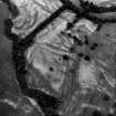
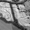
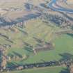
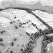
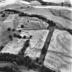
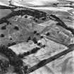
Cutting off the SW portion of the plateau and obiquely traversing the NE third of the larger temporary camp (NO13NW 5.01) there is a linear earthwork, comprising a bank and an external ditch. Traditionally known as the 'Western Vallum', it was first planned by Roy in 1755. During the 1901 excavations (by Abercromby) the height of the rampart was recorded as 1.5m, but in more recent times cultivation has reduced it to a low bank with a barely-detectable hollow on its SW side.
Facing SW, this turf-revetted gravel rampart was originally 6.7m thick, fronted by a V-profile ditch 5.2m wide and 1.7m deep; the rampart and ditch extended unbroken from the very edge of the scarp on the SE, through the SE gate of the labour-camp, to terminate 424m away on the crest of the NW escarpment, with only a slight change of alignment about 180m from the NW end. Its form, position and relationship to the labour-camp show that it is of Roman date but constructed after the evacuation of the camp. The purpose of the work was thus purely tactical, to provide additional protection to the fortress and its occupants while it was still some way from completion.
Information from RCAHMS (JRS) 9 December 1992.
W Roy 1793; J Abercromby, T Ross and J Anderson 1902
Aerial Photographic Interpretation (1 December 2003)
The bank and ditch of this linear earthwork were recorded as a soilmark on oblique aerial photographs in a ploughed field extending SSE from the short surviving upstanding section of the earthwork (RCAHMSAP 2003).
Information from RCAHMS (MMB) 1 December 2003.

