
Hallhole


Enclosure (Prehistoric), Field Boundary (Period Unknown), Pit(S) (Period Unknown), Track(S) (Period Unknown)
Site Name Hallhole
Classification Enclosure (Prehistoric), Field Boundary (Period Unknown), Pit(S) (Period Unknown), Track(S) (Period Unknown)
Canmore ID 28499
Site Number NO13NE 32
NGR NO 18227 39542
NGR Description Centred NO 18227 39542
Datum OSGB36 - NGR
Permalink http://canmore.org.uk/site/28499


- Council Perth And Kinross
- Parish Caputh
- Former Region Tayside
- Former District Perth And Kinross
- Former County Perthshire
Field Visit (28 February 1969)
NO13NE 32 centred NO 18227 39542
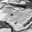
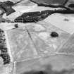
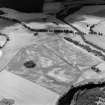
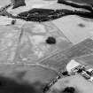
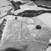
(NO 182 394) Cropmarks, Hallhole near Meikleour visible on St Joseph AP.
No evidence for these cropmarks was seen in a freshly ploughed undulating field. Most of the marks lie in a natural, elongated hollow.
Visited by OS (WDJ) 28 February 1969
Aerial Photographic Transcription (26 January 1989)
An aerial transcription was produced from oblique aerial photographs. Information from Historic Environment Scotland (BM) 31 March 2017.
Aerial Photographic Interpretation (8 December 1992)
Air photography has recorded the cropmark of a roughly circular ditched enclosure 370m NNE of Hallhole farmhouse. It measures about 40m in internal diameter and has opposed entrances on the WNW and ESE. Further cropmarks reveal at least six trackway hollows which cut into the slope to the S of the enclosure and a field boundary.
Information from RCAHMS (JRS) 8 December 1992.

