|
Photographs and Off-line Digital Images |
SC 1156060 |
Historic Scotland Archive Project |
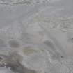
Frame 30A - wooden posts on beach. |
10/1996 |
Item Level |
|
 |
On-line Digital Images |
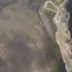
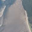
DP 193171 |
RCAHMS Aerial Photography Digital |
Oblique aerial view of the aircraft immobilisation posts on Tentsmuir Sands, looking W. |
30/6/2014 |
Item Level |
|
 |
On-line Digital Images |
DP 194271 |
RCAHMS Aerial Photography Digital |
Oblique aerial view of Aircraft Immobilisation Posts, looking S. |
26/7/2014 |
Item Level |
|
 |
On-line Digital Images |
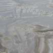
DP 194272 |
RCAHMS Aerial Photography Digital |
Oblique aerial view of Aircraft Immobilisation Posts, looking S. |
26/7/2014 |
Item Level |
|
 |
On-line Digital Images |
DP 194273 |
RCAHMS Aerial Photography Digital |
Oblique aerial view of Aircraft Immobilisation Posts, looking S. |
26/7/2014 |
Item Level |
|
 |
On-line Digital Images |
DP 214535 |
RCAHMS Aerial Photography Digital |
Oblique aerial view of Tentsmuir Aircraft Immobilisation Posts, looking ENE. |
11/6/2015 |
Item Level |
|
|
Manuscripts |
MS 2669/1 |
Historic Scotland Archive Project |
Survey archive: Photographic register for Coastal Assessment Survey for Historic Scotland, Fifeness to Newburgh. Second version of photographic register. |
9/1996 |
Batch Level |
|
|
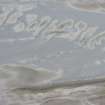
Photographs and Off-line Digital Images |
BP 72/10 |
Historic Scotland Archive Project |
Survey photographs: Tentsmuir Sands showing anti tank blocks, four pillboxes, a navigation marker, wooden posts on the beach, a cork brick structure and metal remains of indeterminate function. |
10/1996 |
Batch Level |
|
|
Manuscripts |
MS 2669/2 |
Historic Scotland Archive Project |
Survey archive: Erosion and Geology map sheets from Coastal Assessment Survey for Historic Scotland, Fifeness to Newburgh.
Map 8 from both Erosion and Geology are not included with the archive. |
9/1996 |
Batch Level |
|


