
Tentsmuir Sands, Aircraft Immobilisation Posts


Anti Glider Posts (20th Century), Fish Trap(S) (Period Unassigned)
Site Name Tentsmuir Sands, Aircraft Immobilisation Posts
Classification Anti Glider Posts (20th Century), Fish Trap(S) (Period Unassigned)
Alternative Name(s) Firth Of Tay; Outer Tay Estuary
Canmore ID 283000
Site Number NO42NE 164
NGR NO 4826 2837
NGR Description Centred NO 480 285
Datum OSGB36 - NGR
Permalink http://canmore.org.uk/site/283000


- Council Fife
- Parish Ferry-port-on-craig
- Former Region Fife
- Former District North East Fife
- Former County Fife
NO42NE 164 centred 480 285
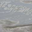
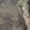
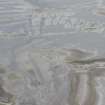
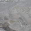
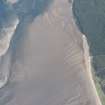
Area of wooden posts.
Type 1: grid lines of large diam. posts set in concrete (glider traps)
Type 2 - thin pointed stakes in line (fish traps (poss)
Site recorded by Maritime Fife during the Coastal Assessment Survey for Historic Scotland, Fife Ness to Newburgh 1996.
Desk Based Assessment (1996)
Area of wooden posts.
Type 1: grid lines of large diam. posts set in concrete (glider traps)
Type 2 - thin pointed stakes in line (fish traps (poss)
Site recorded by Maritime Fife during the Coastal Assessment Survey for Historic Scotland, Fife Ness to Newburgh 1996.

