
Sliabhclachd


Farmhouse (19th Century), Farmstead (19th Century), Kiln Barn (19th Century)
Site Name Sliabhclachd
Classification Farmhouse (19th Century), Farmstead (19th Century), Kiln Barn (19th Century)
Canmore ID 282882
Site Number NJ02SE 29
NGR NJ 06997 20087
Datum OSGB36 - NGR
Permalink http://canmore.org.uk/site/282882


- Council Highland
- Parish Abernethy And Kincardine
- Former Region Highland
- Former District Badenoch And Strathspey
- Former County Inverness-shire
NJ02SE 29 NJ 06997 20087.
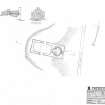
This former farmsteading, now in use as a private residence, contains a cottage that is still occupied, and a range immediately N that is still in use, partly as a kennel, and these were not recorded in detail on the date of visit. In addition there is a range immediately SE of the cottage that has largely collapsed and its interior choked with rubble. However, its N gable still stands to a height of 2m and contains what appears to be cruck-slot in its inner face. Immediately N of this range is a building of which only the SE corner, reduced to footings, survives. A well-preserved kiln-barn stands 43m SE of the cottage. Rectangular on plan, it measures 11.3m from E to W by 4.5m over stone walls that survive to gable height at both ends. The building has been built on a short but steep W-facing slope, and the kiln occupies the lower part, its pot measuring 3.1m in diameter at the top, where there is a narrow ledge or scarcement. At the foot of the gable there is a low arched draw-hole, and the kiln is linked to the barn by a central doorway at the top of the E side of the pot. The barn has opposed doorways in its N and S sides, and there is a cruck-slot in the inner face of the S wall immediately E of the doorway.
All five buildings of this farmsteading are depicted roofed on the 1st edition of the OS 6-inch map (Inverness-shire 1874, sheet XLVIA). The Ordnance Survey Name Book (Inverness-shire, Book 2, p.17) records 'Slibhclach' as 'A farm steading, dwelling house and outhouses one storey high thatched and in tolerable repair, the property of the Earl of Seafield'.
Four buildings were still roofed at the end of the 19th century, only the building now represented by its SE corner being shown unroofed on the 2nd edition of the map (1902, sheet XLVIA).
Visited by RCAHMS (JRS) 22 August 2006.
Project (March 2007)
Detailed measured survey was undertaken in the Braes of Abernethy, Highland, by RCAHMS over the course of one week in March 2007. The archaeological and architectural monuments recorded were identified as worthy of further attention during a survey undertaken in 2006 (see Project Event 555817). The survey was designed to record a representative sample of the sites recorded in 2006, particularly those that were otherwise under-represented in then National Monuments Record of Scotland (now the National Record of the Historic Environment (NRHE)). The Pictish barrow cemetery at Pityoulish is situated outside the area of the original survey, but the opportunity to record it in detail for the first time was thought to be too good a chance to miss. Accordingly two parts of the site were recorded – the group of four ditched mounds at the NE end (Canmore ID 15389) and a solitary kerbed cairn 230m to the SW (Canmore ID 15413).
Information from HES Survey and Recording (JRS) 18 April 2018.
Measured Survey (7 March 2007)
RCAHMS surveyed the kiln barn at Sliabhclachd (NH02SE 29) on 7 March 2007 with plane-table and alidade at a scale of 1:100. The plan was redrawn in vector graphics software at a scale of 1:200.

