
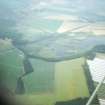
Spynie Canal


Canal (19th Century)
Site Name Spynie Canal
Classification Canal (19th Century)
Alternative Name(s) Lossiemouth; Loch Spynie
Canmore ID 280406
Site Number NJ26NW 26
NGR NJ 2310 6633
NGR Description NJ 1800 6597 to NJ 2370 7043
Datum OSGB36 - NGR
Permalink http://canmore.org.uk/site/280406


- Council Moray
- Parish Drainie
- Former Region Grampian
- Former District Moray
- Former County Morayshire
NJ26NW 26.00 c. 231 658 to 2370 7043
Spynie Canal [NAT] (at NJ 2366 6675)
OS 1:10,560 map, 1970.
Spynie Canal [NAT] (at NJ 2366 7024)
OS 1:10,000 map, 1994.
NJ26NW 26.01 NJ 24569 68705 canal bridge
Extends onto map sheet NJ27SW.
For associated windmill (NJ 23 66), see NJ26NW 29.
For (associated) Spynie, Harbour (NJ c. 231 658), see NJ26NW 33.
For Lossiemouth, Seatown, canal bridge (NJ 23697 70426), see NJ27SW 9.
This canal was dug for land-drainage purposes only.
J Lindsay 1968.
(Location cited as NJ 236 705 to NJ 180 660).
Information from Prof. R Paxton, September 2005.
Loch Spynie is at NJ 2365 6650, immediately SE of the canal.
Information from RCAHMS (RJCM), 11 April 2006.
Construction (1808 - 1812)
Built from 1808–12 to a plan prepared by Telford to drain an area of low-lying land known as Loch Spynie between the town of Elgin and the sea.
R Paxton and J Shipway, 2007.
Reproduced from 'Civil Engineering heritage: Scotland - Highlands and Islands' with kind permission from Thomas Telford Publishers.
Construction (1829)
Damaged by flood 1829. Rebuilt by 1863.
Publication Account (2007)
Spynie Canal
The present canal, about 7 miles long, was built from 1808–12 to a plan prepared by Telford to drain an area of low-lying land known as Loch Spynie between the town of Elgin and the sea. It was an extension of an earlier scheme and had an outfall through sluices into the sea at Lossiemouth. William Hughes was the contractor and the work cost
£12 740.
The canal was badly damaged by a flood in 1829. It was 1860 before reconstruction work eventually commenced. The canal, which had silted up, was deepened, and a heavy masonry outfall structure with four self-acting sluices was built at Lossiemouth. The work costing about £8000 was completed in 1863. Peter MacBey, a local surveyor, acted as engineer.
R Paxton and J Shipway, 2007.
Reproduced from 'Civil Engineering heritage: Scotland - Highlands and Islands' with kind permission from Thomas Telford Publishers.

