|
Prints and Drawings |
DC 5379 |
Records of the Royal Commission on the Ancient and Historical Monuments of Scotland (RCAHMS), Edinbu |
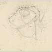
Plane-table survey: fort at Moncrieffe Hill. |
3/5/1953 |
Item Level |
|
|
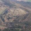
Photographs and Off-line Digital Images |
PT 7510 |
John Dewar |
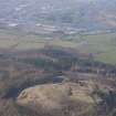
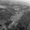
Oblique aerial view of Moredun fort, from the west.
|
2/1971 |
Item Level |
|
|
Photographs and Off-line Digital Images |
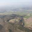
PT 7511 |
John Dewar |
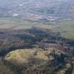
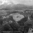
Oblique aerial distant view of Moncreiffe Hill and Moredun forts from west.
|
2/1971 |
Item Level |
|
|
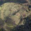
Photographs and Off-line Digital Images |
PT 7538 |
John Dewar |
Oblique aerial view of Moredun fort from the north.
|
2/1971 |
Item Level |
|
|
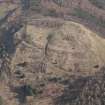
Photographs and Off-line Digital Images |
PT 7539 |
John Dewar |
Oblique aerial view of Moredun fort from the east.
|
2/1971 |
Item Level |
|
|
Photographs and Off-line Digital Images |
C 59163 |
Records of the Royal Commission on the Ancient and Historical Monuments of Scotland (RCAHMS), Edinbu |
Publication plan of Moncrieffe Hill fort. Photographic copy of RCAHMS plan reproduced in Feachem 1955, 80. |
1955 |
Item Level |
|
 |
On-line Digital Images |
DP 115246 |
RCAHMS Aerial Photography Digital |
General oblique aerial view of Moredun fort with the Friarton Bridge and Perth beyond, looking NNW. |
22/3/2012 |
Item Level |
|
 |
On-line Digital Images |
DP 115284 |
RCAHMS Aerial Photography Digital |
Oblique aerial view of Moredun fort, looking SSE. |
22/3/2012 |
Item Level |
|
 |
On-line Digital Images |
DP 115287 |
RCAHMS Aerial Photography Digital |
Oblique aerial view of Moredun fort, looking NW. |
22/3/2012 |
Item Level |
|
 |
On-line Digital Images |
DP 115290 |
RCAHMS Aerial Photography Digital |
Oblique aerial view of Moredun fort, looking SSE. |
22/3/2012 |
Item Level |
|
 |
On-line Digital Images |
DP 115299 |
RCAHMS Aerial Photography Digital |
General oblique aerial view of Moredun fort with the Friarton Bridge and Perth beyond, looking NW. |
22/3/2012 |
Item Level |
|
 |
On-line Digital Images |
DP 115300 |
RCAHMS Aerial Photography Digital |
General oblique aerial view of Moredun fort with the Friarton Bridge and Perth beyond, looking NW. |
22/3/2012 |
Item Level |
|
 |
On-line Digital Images |
DP 157780 |
Records of the Royal Commission on the Ancient and Historical Monuments of Scotland (RCAHMS), Edinbu |
Plane-table survey: fort at Moncrieffe Hill. Photographic copy of DC 5379. |
3/5/1953 |
Item Level |
|
 |
On-line Digital Images |
SC 1402008 |
John Dewar |
Oblique aerial distant view of Moncreiffe Hill and Moredun forts from west.
|
2/1971 |
Item Level |
|
 |
On-line Digital Images |
SC 1402009 |
John Dewar |
Oblique aerial view of Moredun fort from the north.
|
2/1971 |
Item Level |
|
 |
On-line Digital Images |
SC 1402010 |
John Dewar |
Oblique aerial view of Moredun fort, from the west.
|
2/1971 |
Item Level |
|
 |
On-line Digital Images |
SC 1402013 |
John Dewar |
Oblique aerial view of Moredun fort from the east.
|
2/1971 |
Item Level |
|
|
Prints and Drawings |
DC 57647 |
Records of the Royal Commission on the Ancient and Historical Monuments of Scotland (RCAHMS), Edinbu |
Moncrieffe Hill (Carnac, Moredun), Fort, RCAHMS measured survey drawing. |
12/5/2014 |
Item Level |
|
 |
On-line Digital Images |
SC 1425572 |
Records of the Royal Commission on the Ancient and Historical Monuments of Scotland (RCAHMS), Edinbu |
Moncrieffe Hill (Carnac, Moredun), Fort, RCAHMS measured survey drawing. Scanned image of DC 57647. |
12/5/2014 |
Item Level |
|
 |
Digital Files (Non-image) |
WP 003546 |
Oxford Archaeology North |
Hill-Forts of the Inner Tay Estuary. Phase One. Archaeological Survey Report. |
9/2012 |
Item Level |
|
|
Digital Files (Non-image) |
GV 005425 |
Oxford Archaeology North |
CAD files for six surveys. |
9/2012 |
Item Level |
|
|
Digital Files (Non-image) |
GV 005430 |
Oxford Archaeology North |
Survey data; Carnac, Moredun, fort. |
9/2012 |
Item Level |
|
|
Digital Files (Non-image) |
GV 005432 |
Records of the Royal Commission on the Ancient and Historical Monuments of Scotland (RCAHMS), Edinbu |
Publication illustration (Adobe Illustrator file); plan of Moredun Top hillfort. |
26/11/2014 |
Item Level |
|
 |
Digital Files (Non-image) |
WP 003616 |
Records of the Royal Commission on the Ancient and Historical Monuments of Scotland (RCAHMS), Edinbu |
Publication illustration (layered PDF); plan of Moredun Top hillfort. |
26/11/2014 |
Item Level |
|


