 |
Digital Files (Non-image) |
WP 003546 |
Oxford Archaeology North |
Hill-Forts of the Inner Tay Estuary. Phase One. Archaeological Survey Report. |
9/2012 |
Item Level |
|
|
Digital Files (Non-image) |
GV 005425 |
Oxford Archaeology North |
CAD files for six surveys. |
9/2012 |
Item Level |
|
|
Digital Files (Non-image) |
GV 005430 |
Oxford Archaeology North |
Survey data; Carnac, Moredun, fort. |
9/2012 |
Item Level |
|
|
Digital Files (Non-image) |
GV 005432 |
Records of the Royal Commission on the Ancient and Historical Monuments of Scotland (RCAHMS), Edinbu |
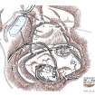
Publication illustration (Adobe Illustrator file); plan of Moredun Top hillfort. |
26/11/2014 |
Item Level |
|
 |
Digital Files (Non-image) |
WP 003616 |
Records of the Royal Commission on the Ancient and Historical Monuments of Scotland (RCAHMS), Edinbu |
Publication illustration (layered PDF); plan of Moredun Top hillfort. |
26/11/2014 |
Item Level |
|
 |
Digital Files (Non-image) |
WP 003618 |
Records of the Royal Commission on the Ancient and Historical Monuments of Scotland (RCAHMS), Edinbu |
RCAHMS Site Description of Moredun Top Fort, Moncrieffe Hill, prepared as a product of a detailed measured survey. |
18/12/2014 |
Item Level |
|
|
Digital Files (Non-image) |
TM 000193 |
Records of the Royal Commission on the Ancient and Historical Monuments of Scotland (RCAHMS), Edinbu |
GNSS linework and control |
2/2014 |
Item Level |
|


