
Blackness, Harbour


Harbour (Period Unassigned)
Site Name Blackness, Harbour
Classification Harbour (Period Unassigned)
Alternative Name(s) Black Ness; Blackness Harbour
Canmore ID 280044
Site Number NT08SE 33
NGR NT 052 801
NGR Description NT c. 052 801
Datum OSGB36 - NGR
Permalink http://canmore.org.uk/site/280044


- Council Falkirk
- Parish Bo'ness And Carriden
- Former Region Central
- Former District Falkirk
- Former County West Lothian
NT08SE 33.00 c. 052 801
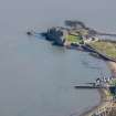
NT08SE 33.01 NT 05173 80122 Pier
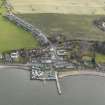
(Location cited as NT 052 801). Blackness, West Lothian. Blackness was a landing-place at least as early as 1304, and in 1389 the 'port' was granted to the Royal Burgh of Linlithgow. In 1465 the burgh was authorised to build a harbour there, with permission to take stones and lime for that purpose from the castle (NT08SE 6.00), the demolition of which was ordered at the same time. The area granted for the port comprised the whole promontory ('montem et rupem') of Blackness to the N of St Ninian's Chapel (NT08SE 10), the site of which is marked on OS maps at the NE end of the village (NT07NE 108), and extending to high-water mark on either side, but it unnecessary to infer that the inclusion of the E side of the promontory implies a connection with the remains noted in the bay to the S of Blackness Castle, seeing that the village and the custom-house (NT08SE 55), as well as St Ninian's Chapel, are all on the W bay. 'Biging and reparatioun of the schore and hewin' were in progress in 1602-4, and in 1710 the place had 'a harbour for all Ships', with a custom-house and warehouses, and ranked as the only safe anchorage in that part of the Firth. Roy's map (1747-55) marks a pier very much in the position of the existing one, but the latter is evidently not the same one as was standing in his day as the harbour was in ruins by 1843, and in 1856 the 25-in OS map marked nothing more than an ill-defined rickle of stones, all below high-water mark. It is only in the edition of 1895 that the pier is given its present form, and its rough irregular masonry, combined with the cemented top and remains of timber fenders, suggests quite recent construction. However, the pier's present length of 220ft [67.1m] may be approximately the same as that of the earlier work; and some of the latter's materials may well have been re-used, particularly the very large boulders on which the seaward end is founded. The structure is now partly ruinous.
A Graham 1971.

