
Unst, Underhoull


Farmstead (Norse), Field System (Period Unassigned), Settlement (Viking), Souterrain (Prehistoric)
Site Name Unst, Underhoull
Classification Farmstead (Norse), Field System (Period Unassigned), Settlement (Viking), Souterrain (Prehistoric)
Alternative Name(s) Kummel Field
Canmore ID 28
Site Number HP50SE 1
NGR HP 5734 0435
Datum OSGB36 - NGR
Permalink http://canmore.org.uk/site/28


- Council Shetland Islands
- Parish Unst
- Former Region Shetland Islands Area
- Former District Shetland
- Former County Shetland
HP50SE 1 5734 0435.
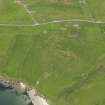
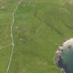
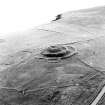
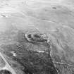
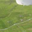
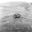
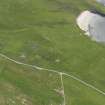
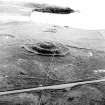
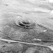
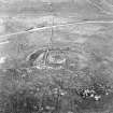
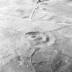
(HP 5733 0438) A habitation site exhibiting evidence of Early Iron Age, Broch period, and Viking occupation, excavated by Small (1967) from 1962 to 1966 under the auspices of RAF Saxa Vord and assisted by Unst Field Club and Aberdeen University Geographical Society.
The original structure on the site was an Early Iron Age hut with an adjacent souterrain covered by a pile of stones.
This was followed, after a definite stratigraphical break by another, larger hut with an associated working area to the SW. The hut was clearly datable by pottery to the period 1st century BC to 2nd century AD, contemporary with the Broch of Underhoull (HP50SE 12) nearby.
Their exact relationship however awaits the excavation of the broch.
The working area produced large quantities of pottery sherds, nodules of worked and partially-worked clay and evidence of iron smelting. There was little or no evidence of a building on the site.
Neither the Early Iron Age nor the broch period hut was fully investigated due to the wish to preserve the massive Viking remains - some of the finest of their type in Scotland.
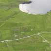
On stratigraphical grounds it is clear that the site was deserted for some considerable time before its reoccupation by a Viking longhouse - a simple, basically self-supporting farmstead. The boat-shaped plan of the building is characteristic of Phase 1 of the Norse settlement at Jarlshof (HU30NE 1), ie AD 800-850. Additions, re-constructions and modifications (including a probable corn-drying chamber at the NE corner of the house) indicate occupation over a considerable time, probably stretching into the 10th century.
A number of small mounds encircle the flat areas around the house. Although covered with field-clearance stones, excavation suggests that they were hay-drying ricks. Local tradition names the site 'Kummel Field,' probably from these mounds.
A small boat noost, 4' deep, occurs near the centre of the head of Burga Bay, but there is no means of dating its construction.
A Small 1967.
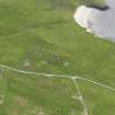
Iron Age - Viking occupation site as described by Small (1967). In the area are numerous field walls and cultivation terraces, many of which will be contemporary with the broch and longhouse but some are fairly modern.
Re-surveyed at 1/2500.
Visited by OS (NKB) 5 May 1969.
Excavation (1962 - 1966)
Excavated by Alan Small, 1962 to 1966.
Sources: A Small 1967; 1968.
Publication Account (1997)
The ramparts and ditches encircling the ruined broch are still very impressive. The Viking farm lies on the slope of the hill about 200m below the broch, with access to the sheltered bay of Lunda Wick. The site was excavated in the 1960s and left open; although overgrown, the walls of the house are still clear, as is some of the stonework of the earlier iron-age farm on top of which the Viking house was built. Although little of the earlier buildings could be traced without demolishing the Viking Age remains, the corner that was exposed had an angular corner and an opening into a small earth-house. This building had been replaced by another in which there was pottery contemporary in date with brochs. This may be a rare example of a 'peasant' dwelling close to a high-status broch.
The site had been deserted for many years before the Norsemen built their hall-house along the contour of the slope. The west end was rounded and the east end had a straight gable, and later annexes were attached to the south wall close to the main doorway. Artefacts from the site included a line-sinker for fishing, fragments of vessels and fragments of gaming boards, all made of steatite; they are in the Shetland Museum, along with an iron axe of Scandinavian type which was found in an eroding midden on the shore of Lunda Wick.
Information from ‘Exploring Scotland’s Heritage: Shetland’, (1997).
Excavation (2007)
HP 5734 0435 As part of the Viking Unst Project, excavation began this year at the potentially Norse house site close to the broch of Underhoull and north east of the site excavated by Small (1966) (RCAHMS HP50SE 32). A topographic survey was undertaken to more clearly define the house and other features in the vicinity. Two trenches were opened to assess the surviving archaeology, in preparation for the full excavation planned for
2008. One trench was positioned across the top of the structure at its western end (Trench A) and a second across the middle of the structure (Trench B) encompassing what appeared to be an annexe or extension to the house.
The southern arc of the top of the house was formed of a double faced stone wall. To the south and butting against this wall a flagged area was uncovered beneath c0.50m of peat. To the south of the flagged area a shallow drain cut into the underlying bedrock and running N/S was recorded. The internal area of the main structure produced a large amount of steatite vessel fragments and a single steatite weight.
A shallow rubble-filled gully was identified, following the curve of the structure on its northern side and being recorded in both trenches A and B adjacent to the wall line. At the northern end of trench A, a layer of slag was revealed that sealed a large area of burning.
In Trench B, a rubble layer sealed the remains of a small U-shaped structure with walls over a metre wide and a small central cell (1.9 x 1.9m), which seems to form an annexe to the main structure. An area of flagging to the south of the annexe was also uncovered with a path leading into the main structure. Two schist whetstones were found on the path and another in the annexe.
Within the area of the main structure excavation ceased when occupation deposits were encountered, in order that their full extent can be excavated next season. In the top of these layers and on the building’s central axis a possible post shadow was identified. Four loom weights were found within Trench B,
including two with crosses carved into their surfaces. Two boundaries to the E and N of the structure were also investigated; these boundaries proved to be constructed of turf and stone, but there is as yet no evidence of their date.
Funder: Heritage Lottery Fund, European Agricultural Guidance and Guarantee Fund (EAGGF), Shetland Development Trust, Shetland Enterprise Company, Shetland Amenity Trust, Historic Scotland, Shetland Islands Council, University of Bradford.
Excavation (2008)
This was the third year of the Viking Unst project which incorporates the excavation of Viking longhouses at Hamar, Belmont and Underhoull. Work at Hamar and Underhoull was drawn to a conclusion, with a further season proposed for Belmont.
HP 5734 0435 - Underhoull Upper House, Westings - This season assessment trenches excavated in 2007 were extended. It is now known that the Upper House is quite similar in plan to the original house excavated at
Underhoull (Small 1966), with two annexes on the southern (seaward) side of the building. Investigation of the structure showed that it was constructed with a stone frontage on the southern long wall and western gable, while the northern upslope side had a turf and stone construction with a gully running along the northern long wall. The southern side of the building faces down slope and towards the sea and so would be the most exposed face. The southern side is also the most likely direction of access to the structure. The two annexes flank the entrance on the southern side and there are areas of flagging here also.
The upper part of the house had a floor constructed partly of flagstones and partly of the natural bedrock. This was sealed by a deposit containing the highest concentration of artefacts on the site. This included a large quantity of steatite with fragments of large vessels, pottery fragments and an unfinished steatite lamp. The mid part of the building was largely sterile in terms of finds, though two line sinkers of steatite were found in this area. Lines of flagstones butting the long walls in this area suggest the possibility that there was a sprung timber floor.
The two annexes proved to have more than one phase, with multiple occupation surfaces sealing hearths in both rooms. Samples have been taken for archaeomagnetic dating. A turf-walled enclosure to the N of the building and connected to it externally was also investigated; small fragments of steatite and charcoal were the only finds recovered from this area. It is possible that this area formed a small yard or work space.
The peat growth which covered the flagging on the south side of the structure was also further investigated this year, with sampling for pollen, tephra and other analyses. The date and nature of this peat growth is still under investigation. Post-excavation work and dating of the Hamar and Underhoull structures is continuing.
British and Danish sponsors, funding bodies and support: European Agricultural Guidance and Guarantee Fund, Heritage Lottery Fund, Historic Scotland, Shetland Amenity Trust, Shetland Development Trust, Shetland Enterprise Company, Shetland Islands Council, The Viking Ship Museum in Roskilde, University of Aberdeen, University of Bradford and University of Copenhagen
J M Bond, A C Larson and V E Turner, 2008

