
Union Canal, Roughcastle Tunnel


Tunnel (Period Unassigned)
Site Name Union Canal, Roughcastle Tunnel
Classification Tunnel (Period Unassigned)
Alternative Name(s) Rough Castle Tunnel; New Falkirk Tunnel; Edinburgh And Glasgow Union Canal; Antonine Wall; Millennium Link; Falkirk Wheel
Canmore ID 279405
Site Number NS87NE 31.05
NGR NS 85257 79848
NGR Description NS 85257 79848 to NS 85264 79684
Datum OSGB36 - NGR
Permalink http://canmore.org.uk/site/279405


- Council Falkirk
- Parish Falkirk
- Former Region Central
- Former District Falkirk
- Former County Stirlingshire
NS87NE 31.05 85257 79848 to 85264 79684
Roughcastle Tunnel [NAT]
OS AIB (GIS) February 2006.
Not to be confused with (original) Falkirk Tunnel (at Hallglen: NS 88141 78983 to NS 88390 78400), for which see NS87NE 31.01.
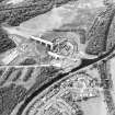
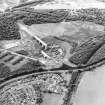
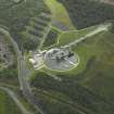
This tunnel was built as part of the Millennium Link project to carry the Edinburgh and Glasgow Union Canal (NS87NE 31.00: LIN 18) beneath the Antonine Wall (NS87NE 57.01), the Edinburgh-Glasgow (main) railway line, and Bonnyhill Road. It thus forms the southern approach to the Falkirk Wheel (NS88SE 198).
The tunnel is short, straight and of circular section. The sides have been formed by sprayed concrete, and both entrances are of simple form. There is a railed footpath on the E side of the waterway.
Information from RCAHMS (RJCM), 2 March 2006.

