
North Uist, Carinish, Cnoc Nan Aingeal 2


Cairn (Period Unassigned)
Site Name North Uist, Carinish, Cnoc Nan Aingeal 2
Classification Cairn (Period Unassigned)
Canmore ID 279393
Site Number NF86SW 72
NGR NF 81855 60527
Datum OSGB36 - NGR
Permalink http://canmore.org.uk/site/279393


- Council Western Isles
- Parish North Uist
- Former Region Western Isles Islands Area
- Former District Western Isles
- Former County Inverness-shire
Field Visit (13 August 1915)
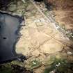
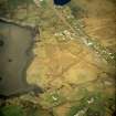
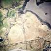
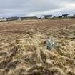
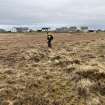
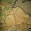
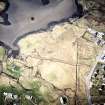
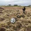
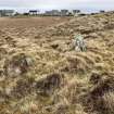
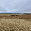
Cairn, Cnoc nan Aingeal, Carinish.
On the summit of a rocky hillock, Cnoc nan Aingeal, rising from the shore some 300 yards north-north-east of Teampull na Trionaid at Carinish, is a small cairn of stones, 12 feet in diameter, and 2 feet in height. In the adjoining marshy hollow to the east is a circular knoll, apparently rocky and natural, rising about 10 feet in height, which is surrounded a few feet from its base by a ring of stones placed in a low bank of earth. The stones have a general height of about 2 feet, are placed a few feet apart, and are very numerous on the south and west sides. The space enclosed by them measures about 110 feet from west-north-west to east-southeast, and some 102 feet across.
RCAHMS 1928, visited 13 August 1915.
OS map: North Uist xxxix (unnoted).

