
Preston Island, Naval Sf/ql Decoy Control Bunker


Decoy Site (20th Century)
Site Name Preston Island, Naval Sf/ql Decoy Control Bunker
Classification Decoy Site (20th Century)
Alternative Name(s) Ro5; High Valleyfield; River Forth; Inner Forth Estuary
Canmore ID 278289
Site Number NT08NW 134
NGR NT 0077 8554
NGR Description NT c. 0077 8554
Datum OSGB36 - NGR
Permalink http://canmore.org.uk/site/278289


- Council Fife
- Parish Culross
- Former Region Fife
- Former District Dunfermline
- Former County Fife
NT08NW 134 c. 0077 8554
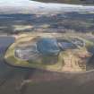
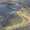
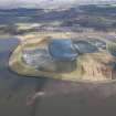
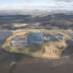
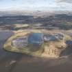
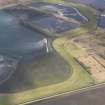
The control bunker for a Naval Starfish and small fire decoy site is visible on vertical air photographs (106G/UK 983, 3032-3033, flown 8 November 1945), situated on coal waste tips (bings) about 300m NE of Preston Island. The bunker is rectangular in plan with the entrance on the E side. There is no evidence on the air photographs of the decoy siteand as the images were taken at high tide, it is not certain whether the decoy was on the tidal flats between Preston Island and the waste tip or on the tip itself.
The decoy covered Rosyth and was designated code RO5 by the War Office.
The bunker has subsequently been covered by further coal waste and ash tipping in the area or demolished.
Information from RCAHMS (DE), January 2006.

