
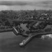
Peterhead Harbour, Port Henry Harbour


Harbour (Period Unassigned)
Site Name Peterhead Harbour, Port Henry Harbour
Classification Harbour (Period Unassigned)
Alternative Name(s) Seagate
Canmore ID 278073
Site Number NK14NW 128.04
NGR NK 1364 4630
NGR Description Centred NK 1364 4630
Datum OSGB36 - NGR
Permalink http://canmore.org.uk/site/278073


- Council Aberdeenshire
- Parish Peterhead
- Former Region Grampian
- Former District Banff And Buchan
- Former County Aberdeenshire
Publication Account (2007)
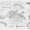
Port Henry Harbour
The first breakwater sheltering this harbour was constructed in ca.1600, and the harbour remained almost unchanged until 1878. About this time D. & T. Stevenson submitted a plan for a new pier, Port Henry Pier, and a new
quay along the harbour’s south-west quadrant adjoining Birnie’s Pier, enclosing an area of about 5 acres.
The Model Pier, dividing the harbour, was constructed from 1873–78, and in ca.1905 Birnie’s pier was modified and a new entrance formed which gave the harbour its present configuration.
R Paxton and J Shipway, 2007.
Reproduced from 'Civil Engineering heritage: Scotland - Highlands and Islands' with kind permission from Thomas Telford Publishers.

