
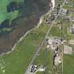
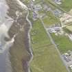
Westray, Pierowall, Lady Kirk


Burial Ground (Medieval) - (Post Medieval), Church (17th Century), Gravestone(S) (17th Century)
Site Name Westray, Pierowall, Lady Kirk
Classification Burial Ground (Medieval) - (Post Medieval), Church (17th Century), Gravestone(S) (17th Century)
Alternative Name(s) Pierowall, St Mary's Kirk; Pierowall Church
Canmore ID 2775
Site Number HY44NW 2
NGR HY 43949 48822
Datum OSGB36 - NGR
Permalink http://canmore.org.uk/site/2775

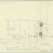
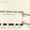
![Publication drawing; plan of Pierowall Church. [Draft]](http://i.rcahms.gov.uk/canmore/l/DP00216051.jpg)


![Publication drawing; plan of Pierowall Church. [Draft]](http://i.rcahms.gov.uk/canmore/s/DP00216051.jpg)
- Council Orkney Islands
- Parish Westray
- Former Region Orkney Islands Area
- Former District Orkney
- Former County Orkney
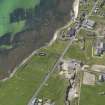
HY44NW 2 43949 48822.
(HY 4396 4882) Church (NAT) (In Ruins).
OS 6" map, Orkney, 2nd ed., (1900).
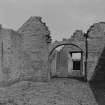
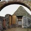
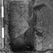
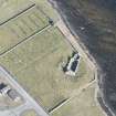
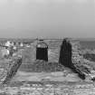
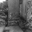
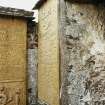
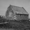
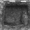
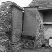
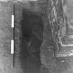
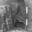
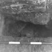
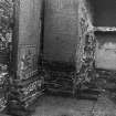
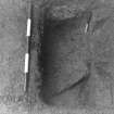
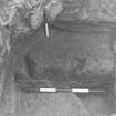
The remains of the Lady Kirk (J R Tudor 1883), built in the 13th century, but restored to such an extent in the 17th century, that the only original building left is the lowest 8' of the south wall of the nave, the footing of the west gable and part of the wall that contains the chancel arch.
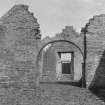
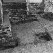
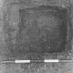
The church comprises a rectangular nave and a chancel which is canted southwards. The masonry is rubble with freestone dressings and is lime mortared except for the older work which seems to have been bedded in clay. The walls are complete although on the outside, except at the NE angle, they are partly concealed by accumulation of soil.
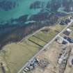
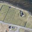
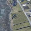
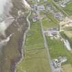
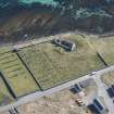
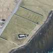
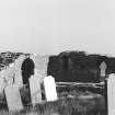
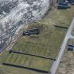
This was the parish church, and the graveyard, which surrounds it, was stil in use in 1879.
Name Book 1880; RCAHMS 1946, visited 1930.
Lady Kirk (as on Historic Buildings and Monuments {Ministry of Works} plaque), as described, planned and illustrated.
Visited by OS (RL) 27 June 1970.
Field Visit (June 1931)
Lady Kirk HY 4395 4881 HY44NW 2
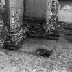
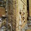
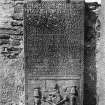
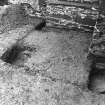
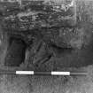
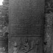
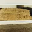
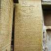
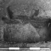
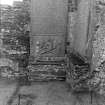
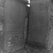
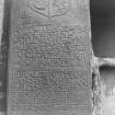
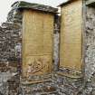
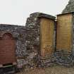
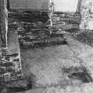
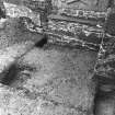
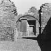
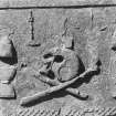
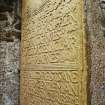
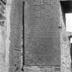
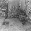
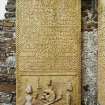
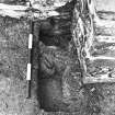
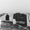
The very irregularly-shaped bicameral church, situated near the centre of Pierowall village, was very heavily remodelled in the seventeenth century as confirmed by an epigraphic date of 1674. Two particularly fine graveslabs of this period are set in the interior walls of the chancel. The S wall of the nave, which is earlier than the remainder, may be of medieval date.
RCAHMS 1983, visited June 1981.
(Name Book, Orkney, No. 26, p. 99; Tudoe 1883, 374; RCAMS 1946, ii, pp. 343-4, No. 1030; OR 913).
Publication Account (1996)
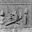
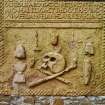
There are traces of the medieval fabric in the walls of this church, but most of the visible structure was built in the late 17th century, and the date of 1674 is carved on the south skewput (the lowest stone at eaves level) of the east gable. The nave was realigned, somewhat wider than before, and the chancel was replaced by a laird 's aisle, the whole structure di stinctly canted. The west gable is stopped by a 'birdcage' bellcote with a ball finial. Within the laird 's aisle are two 17th-century tombstones with exceptionally fine lettering, one of which has the emblems of mortality carved in high relief and an effective chequered margin.
Information from ‘Exploring Scotland’s Heritage: Orkney’, (1996).
Field Visit (1998)
Lady Kirk, built in the 13th C, was extensively restored in the 17th C and is now ruinous. The nave was originally 14.5m long by 5.8m wide but was later widened by 0.5m. Because of the restoration, the church is of a very irregular rectangular plan and the chancel is out of alignement with the nave. The church is surrounded by a graveyard which contains several interesting slabs of 18th C date. It also contains a large grass-covered mound which may cover further structural remains. Two carved grave slabs of 17th C date are set into the interior walls of the church and are protected by glass screens. This served as the parish church and graveyard and remained in use until 1879. It is probable that there was an earlier church either on the same spot or nearby; the Orkneyinga Saga relates that Rognvald went to church at Pierowall at the start of his campaign to subjugate Orkney in 1136.
Moore and Wilson, 1998
Coastal Zone Assessment Survey

