
Strathmashie Forest, Tirfadoun South 1


Farmstead (Period Unassigned)
Site Name Strathmashie Forest, Tirfadoun South 1
Classification Farmstead (Period Unassigned)
Canmore ID 276775
Site Number NN59SE 35
NGR NN 5856 9286
Datum OSGB36 - NGR
Permalink http://canmore.org.uk/site/276775

- Council Highland
- Parish Laggan
- Former Region Highland
- Former District Badenoch And Strathspey
- Former County Inverness-shire
NN59SE 35 5856 9286
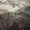
The scant remains of a number of structures were recorded here during a detailed desktop and walkover survey of Strathmashie Forest ahead of a proposed heritage trail. Enough archaeological features were found to make the trail worthwhile. All the structures are on the N side of a modern track. The northernmost structure is rectangular and measures around 10m x 4.5m. Only occasional stone is visible through the turf covering and no entrance is apparent. Just to the E is a well-defined rectangular hollow, 3m x 4.5m. It appears to have been cut into the ground. To the S are two other structures. One is rectangular and measures 4m x 2.5m. Just to the E is a curvilinear feature defined by a turf and moss-covered bank with occasional stone visible. The features of this group could be interpreted as a small farmstead, comprising two buildings, an enclosure and a small hollow that may have been a storage area.
D Sneddon 2005

