
Errol Airfield, Technical Site


Building(S) (20th Century), Hut (20th Century), Parachute Packing Building (20th Century)
Site Name Errol Airfield, Technical Site
Classification Building(S) (20th Century), Hut (20th Century), Parachute Packing Building (20th Century)
Alternative Name(s) Muirhouses
Canmore ID 275314
Site Number NO22SE 18.04
NGR NO 2705 2490
NGR Description Centred NO 2705 2490
Datum OSGB36 - NGR
Permalink http://canmore.org.uk/site/275314

- Council Perth And Kinross
- Parish Errol
- Former Region Tayside
- Former District Perth And Kinross
- Former County Perthshire
NO22SE 18.04 centred 2705 2490
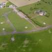
Several extant buildings that formerly lay within the technical area have been noted on the NE corner of the airfield. The area is visible on RAF WW II vertical air photographs (NLA 68, 3089-3092, flown 27 August 1943) and in addition to the group of buildings were two aircraft hangars (c.NO 2682 2473 and c.NO 2716 2478), possibly of T1 type.
Most of the buildings in this area were huts, probably of wood or asbestos construction, some of which formed conjoined units.
Surviving 1939-1945 period huts and buildings have been noted at NO 27050 24911, NO 26980 24867, NO 27000 24776 and NO 27097 24931, but the two aircraft hangars and many other structures are not visible on vertical air photographs taken in 1988 (All Scotland Survey, 50788 226-227, flown 10 June 1988).
Information from RCAHMS (DE), October 2005

