
South Uist, West Geirinis, Rangehead


Radio Mast(S) (20th Century)
Site Name South Uist, West Geirinis, Rangehead
Classification Radio Mast(S) (20th Century)
Canmore ID 274478
Site Number NF74SE 31.02
NGR NF 75734 42591
NGR Description Centred NF 75734 42591
Datum OSGB36 - NGR
Permalink http://canmore.org.uk/site/274478


- Council Western Isles
- Parish South Uist
- Former Region Western Isles Islands Area
- Former District Western Isles
- Former County Inverness-shire
NF74SE 31.02 centred 75734 42591
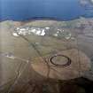
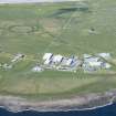
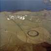
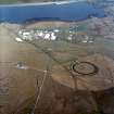
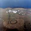
Radio masts set within a circular banked enclosure both situated within a larger circular fenced enclosure. Used to monitor ranges.
The circular area is visible on vertical air photographs (All Scotland Survey, 04 87 161-163, flown 22 May 1987).
Information from RCAHMS (DE), August 2005

