
Craigsheal Burn


Building(S) (Medieval) - (Post Medieval), Hut Circle(S) (Prehistoric)
Site Name Craigsheal Burn
Classification Building(S) (Medieval) - (Post Medieval), Hut Circle(S) (Prehistoric)
Canmore ID 27369
Site Number NO05SE 12
NGR NO 06044 52062
Datum OSGB36 - NGR
Permalink http://canmore.org.uk/site/27369


- Council Perth And Kinross
- Parish Clunie
- Former Region Tayside
- Former District Perth And Kinross
- Former County Perthshire
Field Visit (6 February 1975)
NO05SE 12 0604 5204.
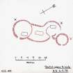
At NO 0604 5204 on a S-facing slope is a settlement of three hut circles ('A'-'C') at the head of a contemporary field system marked by stone clearance heaps, lynchets and stone walls.
'A' measures 15.5m between wall centres. The entrance is in the SSE. A rectangular building (5.0m x 3.0m) has been built in its interior.
'B' is a poorly preserved double-walled hut 8.3m internally and 16.0m E-W between outer wall centres, with the entrance in the ESE. The inner wall has been overlaid by a rectangular building measuring 4.0 x 2.5m. The outer wall expands on the S and joins 'A' forming a courtyard between them, in which is another rectangular foundation.
'C' is a well-preserved single-walled hut which appears to have been partly set into the NE arc of 'B' and is thus later. The entrance is on the ESE. It measures 9.5m in diameter between centres of a rubble wall 1.3m wide which shows no facing stones.
Surveyed at 1/10,000.
Visited by OS (SFS) 6 February 1975
Field Visit (17 June 1987)
Situated on the W bank of the Craigsheal Burn, on a narrow terrace close to the foot of the SE flank of Spurn Hill, there is a group of three hut-circles. On the date of visit they lay in very thick heather and measurements have been taken from an OS sketch plan.
1. NO 0603 5203 (OS 'A') The southernmost hut-circle is double-walled and measures about 8.5m in internal diameter and 17m overall. The internal wall has been reduced to little more than a slight scarp in places, and may have been robbed to provide material for the construction of the small rectangular building (c. 5.5m NE-SW by 3m overall) whose footings overlie the SE part of the hut-circle. The entrance to the hut-circle is on the SE.
2. NO 0604 5206 (OS 'B') To the NNW there are the remains of a second double-walled hut-circle whose outer wall has been extended S to join the outer wall of (1) and form an enclosure between the two hut-circles. It measures some 8.3m in internal diameter and 16m overall. There is a splayed entrance on the SE, and on the E the outer wall has been destroyed by the construction of hut-circle (3). A building (c.4.5m NE-SW by 2.5m overall) overlies the N side of the interior of the hut-circle and within the area enclosed by the outer wall there are the footings of another (about 7m NE-SW by 3m overall).
3. NO 0606 5206 (OS 'C') This single-walled hut-circle measures about 8.5m in diameter within a low rubble wall and has an entrance on the SE. A few cairns and stony banks were noted on the slopes to the SE of the hut-circle.
Visited by RCAHMS (JRS) 17 June 1987.
RCAHMS 1990

