 |
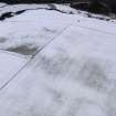
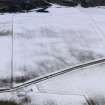
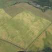
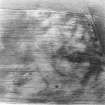
On-line Digital Images |
DP 086441 |
RCAHMS Aerial Photography Digital |
Oblique aerial view of the snow marks of the settlement at Black Loch, taken from the SE. |
23/2/2010 |
Item Level |
|
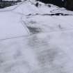 |
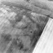
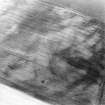
On-line Digital Images |
DP 086442 |
RCAHMS Aerial Photography Digital |
Oblique aerial view of the snow marks of the settlement at Black Loch, taken from the E. |
23/2/2010 |
Item Level |
|
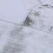 |
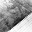
On-line Digital Images |
DP 086443 |
RCAHMS Aerial Photography Digital |
Oblique aerial view of the snow marks of the settlement at Black Loch, taken from the ENE. |
23/2/2010 |
Item Level |
|
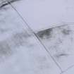 |
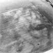
On-line Digital Images |
DP 086445 |
RCAHMS Aerial Photography Digital |
Oblique aerial view of the snow marks of the settlement at Black Loch, taken from the NNE. |
23/2/2010 |
Item Level |
|
 |
On-line Digital Images |
DP 086449 |
RCAHMS Aerial Photography Digital |
Oblique aerial view of the snow marks of the settlement at Black Loch, taken from the SSE. |
23/2/2010 |
Item Level |
|
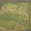 |
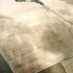
On-line Digital Images |
DP 163227 |
RCAHMS Aerial Photography Digital |
Oblique aerial view of the cropmarks of the settlement enclosure and the possible round house, looking NNW. |
27/7/2013 |
Item Level |
|
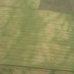 |
On-line Digital Images |
DP 163228 |
RCAHMS Aerial Photography Digital |
Oblique aerial view of the cropmarks of the settlement enclosure and the possible round house, looking WSW. |
27/7/2013 |
Item Level |
|
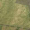 |
On-line Digital Images |
DP 163229 |
RCAHMS Aerial Photography Digital |
Oblique aerial view of the cropmarks of the settlement enclosure and the possible round house, looking SW. |
27/7/2013 |
Item Level |
|
 |
On-line Digital Images |
DP 163249 |
RCAHMS Aerial Photography Digital |
Oblique aerial view of the cropmarks of the settlement enclosure and the possible round house, looking NNW. |
27/7/2013 |
Item Level |
|
 |
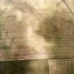
On-line Digital Images |
SC 1748356 |
RCAHMS Aerial Photography |
Oblique aerial view centred on the cropmarks of the linear cropmarks, pits and possible roundhouse, taken from the SE. |
12/8/1999 |
Item Level |
|
 |
On-line Digital Images |
SC 1748485 |
RCAHMS Aerial Photography |
Oblique aerial view centred on the cropmarks of the linear cropmarks, pits and possible roundhouse, taken from the ESE. |
12/8/1999 |
Item Level |
|
 |
On-line Digital Images |
SC 1748486 |
RCAHMS Aerial Photography |
Oblique aerial view centred on the cropmarks of the possible settlement, linear cropmarks, pits and possible roundhouse, taken from the E. |
12/8/1999 |
Item Level |
|
 |
On-line Digital Images |
SC 1748487 |
RCAHMS Aerial Photography |
Oblique aerial view centred on the cropmarks of the possible settlement, linear cropmarks, pits and possible roundhouse, taken from the ENE. |
12/8/1999 |
Item Level |
|
 |
On-line Digital Images |
SC 1748488 |
RCAHMS Aerial Photography |
Oblique aerial view centred on the cropmarks of the possible settlement, linear cropmarks, pits and possible roundhouse, taken from the NE. |
12/8/1999 |
Item Level |
|
 |
On-line Digital Images |
SC 1748560 |
RCAHMS Aerial Photography |
Oblique aerial view centred on the cropmarks of the possible settlement with the cropmarks of the round house and pits adjacent, taken from the W. |
22/7/2003 |
Item Level |
|
 |
On-line Digital Images |
SC 1748561 |
RCAHMS Aerial Photography |
Oblique aerial view centred on the cropmarks of the possible settlement with the cropmarks of the round house and pits adjacent, taken from the WSW. |
22/7/2003 |
Item Level |
|
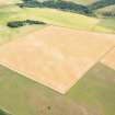 |
On-line Digital Images |
DP 284349 |
Historic Environment Scotland |
Oblique aerial view. |
17/7/2018 |
Item Level |
|
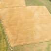 |
On-line Digital Images |
DP 284350 |
Historic Environment Scotland |
Oblique aerial view. |
17/7/2018 |
Item Level |
|


