
Daill


Farmstead (Period Unassigned)
Site Name Daill
Classification Farmstead (Period Unassigned)
Canmore ID 272929
Site Number NC36NE 98
NGR NC 3583 6822
Datum OSGB36 - NGR
Permalink http://canmore.org.uk/site/272929


- Council Highland
- Parish Durness
- Former Region Highland
- Former District Sutherland
- Former County Sutherland
NC36NE 98 3583 6822
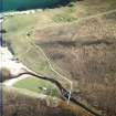
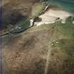
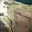
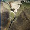
This farmsteading, comprising two roofed buildings and adjacent enclosures, has been recorded on oblique aerial photography (RCAHMSAP 2004) lying close to the shore on the N bank of the Daill River. It is depicted on the 1st edition of the OS 6-inch map (Sutherland 1878, Sheet V) as two roofed buildings and two enclosures.
Information from RCAHMS (KMM) 21 April 2005

