
Lewis, Uamh'a Ghobha


Church (20th Century)
Site Name Lewis, Uamh'a Ghobha
Classification Church (20th Century)
Alternative Name(s) Filiscleitir; Dune Tower
Canmore ID 272576
Site Number NB55NE 16
NGR NB 56136 57479
Datum OSGB36 - NGR
Permalink http://canmore.org.uk/site/272576


- Council Western Isles
- Parish Barvas
- Former Region Western Isles Islands Area
- Former District Western Isles
- Former County Ross And Cromarty
NB55NE 16 56136 57479
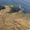
This unroofed building, depicted on the current edition of the OS 1:10000 map (1973) but not shown on the 1st edition of the OS 6-inch map (Island of Lewis Ross-shire 1853, sheet 6), has been recorded on oblique aerial photography (RCAHMSAP 2004) lying on the headland above Uamh'a Ghobha.
Information from RCAHMS (KMM) 23 May 2005

