
Thrumster, Sarclet


Runway (20th Century)
Site Name Thrumster, Sarclet
Classification Runway (20th Century)
Alternative Name(s) Q/k; Rose Cottage; Mains Of Ulbster, Hillhead, Borrowston
Canmore ID 271635
Site Number ND34SW 311.10
NGR ND 336 435
NGR Description ND 336 435
Datum OSGB36 - NGR
Permalink http://canmore.org.uk/site/271635


- Council Highland
- Parish Wick
- Former Region Highland
- Former District Caithness
- Former County Caithness
Field Visit (24 August 2004)
ND34SW 311.10 336 435
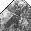
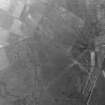
A complex of dummy runways, taxiing strips and service roads was created in peaty moorland by a mixture of quarry dust and lime, probably after the heather was removed. The complex extends from the road between Thrumster village and Mains of Ulbster Farms on the E to at least the edge of the drier, improved fields on Borrowston farm on the W, covering an area measuring 920m from NW to SE by 880m transversely. The three dummy runways are aligned N to S, NW to SE, and NE to SW respectively, and are enclosed by a dummy perimeter road. Two oval-shaped areas, one on the NW side of the complex and the other on the SE side, may have been created to give the impression of taxiing stances.
Visited by RCAHMS (ATW) 24 August 2004

