|
Prints and Drawings |
DC 37369 |
Papers of Professor John Kenneth Sinclair St Joseph, archaeologist, Histon, Cambridgeshire, England |
Gask Ridge.
Locational map of forts and signal towers. |
|
Item Level |
|
|
Prints and Drawings |
DC 37370 |
Papers of Professor John Kenneth Sinclair St Joseph, archaeologist, Histon, Cambridgeshire, England |
Gask Ridge signal stations.
Comparative plans. |
|
Item Level |
|
|
Prints and Drawings |
DC 37371 |
Papers of Professor John Kenneth Sinclair St Joseph, archaeologist, Histon, Cambridgeshire, England |
Gask Ridge signal stations.
Comparative plans. |
|
Item Level |
|
|
Prints and Drawings |
DC 37372 |
Papers of Professor John Kenneth Sinclair St Joseph, archaeologist, Histon, Cambridgeshire, England |
Gask Ridge Signal Stations.
Comparative table of dimensions. |
|
Item Level |
|
|
Photographs and Off-line Digital Images |
DP 011249 |
General Collection |
Oblique aerial view of Midgate, ditch showing, from NW (aircraft at c.NO 020 208). |
7/8/2000 |
Item Level |
|
|
Photographs and Off-line Digital Images |
DP 011250 |
General Collection |
Oblique aerial view of Midgate, ditch showing, from NW (aircraft at c.NO 019 206). |
7/8/2000 |
Item Level |
|
|
Photographs and Off-line Digital Images |
DP 011251 |
General Collection |
Oblique aerial view of Midgate, ditch showing, from NW (aircraft at c.NO 019 206). |
7/8/2000 |
Item Level |
|
|
Photographs and Off-line Digital Images |
DP 011288 |
General Collection |
Oblique aerial view of Midgate, ditch shows faintly, from N (aircraft at c.NO 019 206). |
7/8/2000 |
Item Level |
|
|
Photographs and Off-line Digital Images |
DP 011289 |
General Collection |
Oblique aerial view of Midgate, ditch shows faintly, from N (aircraft at c.NO 019 204). |
7/8/2000 |
Item Level |
|
 |
On-line Digital Images |
SC 2394851 |
Records of the Ordnance Survey, Southampton, Hampshire, England |
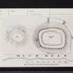
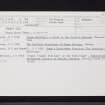
Thorny Hill, NO02SW 6, Ordnance Survey index card, Recto |
1958 |
Item Level |
|
 |
On-line Digital Images |
SC 2394852 |
Records of the Ordnance Survey, Southampton, Hampshire, England |
Thorny Hill, NO02SW 6, Ordnance Survey index card, Recto |
1958 |
Item Level |
|
 |
On-line Digital Images |
SC 2394853 |
Records of the Ordnance Survey, Southampton, Hampshire, England |
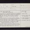
Thorny Hill, NO02SW 6, Ordnance Survey index card, page number 1, Recto |
1958 |
Item Level |
|
 |
On-line Digital Images |
SC 2394854 |
Records of the Ordnance Survey, Southampton, Hampshire, England |
Thorny Hill, NO02SW 6, Ordnance Survey index card, page number 2, Verso |
1958 |
Item Level |
|
 |
On-line Digital Images |
SC 2394855 |
Records of the Ordnance Survey, Southampton, Hampshire, England |
Thorny Hill, NO02SW 6, Ordnance Survey index card, Recto |
1958 |
Item Level |
|
|
All Other |
551 166/1/1 |
Records of the Ordnance Survey, Southampton, Hampshire, England |
Archaeological site card index ('495' cards) |
1947 |
Sub-Group Level |
|


