
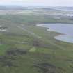
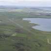
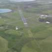
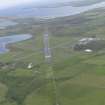
Kirkwall Aerodrome


Control Tower (20th Century)
Site Name Kirkwall Aerodrome
Classification Control Tower (20th Century)
Alternative Name(s) Grimsetter Airfield; Hms Robin
Canmore ID 269188
Site Number HY40NE 27.05
NGR HY 48018 08021
Datum OSGB36 - NGR
Permalink http://canmore.org.uk/site/269188


- Council Orkney Islands
- Parish St Andrews And Deerness
- Former Region Orkney Islands Area
- Former District Orkney
- Former County Orkney
HY40NE 27.05 48018 08021
The WW II control tower is situated in a grass area about 150m S of the crossing point of all three runways. The original tower has been altered by the addition of a 'glasshouse' on top.
Internally the WW II tower retains some contemporary features, but many of the rooms have been altered to suit modern technology.
On the date of visit a new tower was under construction , which when completed, will render the WW II version redundant. It is not known whether this will lead to the demolition of the old tower.
The control tower is visible on RAF vertical air photographs (LEU/UK2, 7117-7121, flown 16 April 1948).
Visited by RCAHMS (DE, SW), August 2000.

