 |
On-line Digital Images |
SC 1704887 |
RCAHMS Aerial Photography |
Oblique aerial view. |
1988 |
Item Level |
|
 |
On-line Digital Images |
SC 1704888 |
RCAHMS Aerial Photography |
Oblique aerial view. |
1988 |
Item Level |
|
 |
On-line Digital Images |
SC 1704913 |
RCAHMS Aerial Photography |
Oblique aerial view. |
1992 |
Item Level |
|
 |
On-line Digital Images |
SC 1704991 |
RCAHMS Aerial Photography |
Oblique aerial view. |
1977 |
Item Level |
|
 |
On-line Digital Images |
SC 1704992 |
RCAHMS Aerial Photography |
Oblique aerial view. |
1977 |
Item Level |
|
 |
On-line Digital Images |
SC 1704993 |
RCAHMS Aerial Photography |
Oblique aerial view. |
1977 |
Item Level |
|
 |
On-line Digital Images |
SC 1705044 |
RCAHMS Aerial Photography |
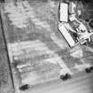
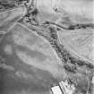
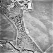
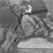
Leadketty, oblique aerial view, taken from the SSW, centred on the cropmark of an enclosure. An alignment of pits running from it towards the top of the photograph is part of a large pit-defined enclosure. Further pits are visible in the top half. |
13/7/1995 |
Item Level |
|
 |
On-line Digital Images |
SC 1705045 |
RCAHMS Aerial Photography |
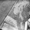
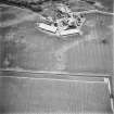
Leadketty, oblique aerial view, taken from the SE, centred on the cropmark of an enclosure. An alignment of pits running from it towards the top right-hand corner of the photograph is part of a large pit-defined enclosure. |
13/7/1995 |
Item Level |
|
 |
On-line Digital Images |
SC 1705046 |
RCAHMS Aerial Photography |
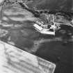
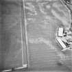
Leadketty, oblique aerial view, taken from the WNW, centred on the cropmark of an enclosure. An alignment of pits in the centre left of the photograph is part of a large pit-defined enclosure. |
13/7/1995 |
Item Level |
|
 |
On-line Digital Images |
SC 1705055 |
|
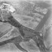
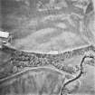
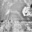
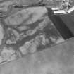
Leadketty, oblique aerial view, taken from the NNW, centred on the cropmarks of a possible henge, ring-ditches and pits. The cropmarks of two enclosures and pits are visible in the top half of the photograph. |
12/7/1996 |
Item Level |
|
 |
On-line Digital Images |
SC 1705056 |
|
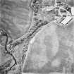
Leadketty, oblique aerial view, taken from the WSW, centred on the cropmarks of a possible henge, ring-ditches and pits. The cropmarks of an enclosure, pits and parts of a pit-defined enclosure are visible in the top half of the photograph. |
12/7/1996 |
Item Level |
|
 |
On-line Digital Images |
SC 1705058 |
|
Leadketty, oblique aerial view, taken from the SSE, centred on the cropmarks of an enclosure, a possible enclosure, pits and parts of a pit-defined enclosure. |
12/7/1996 |
Item Level |
|
 |
On-line Digital Images |
SC 1705059 |
|
Leadketty, oblique aerial view, taken from the ESE, centred on the cropmarks of an enclosure and parts of a pit-defined enclosure. |
12/7/1996 |
Item Level |
|
 |
On-line Digital Images |
SC 1705060 |
|
Leadketty, oblique aerial view, taken from the NE, centred on the cropmarks of an enclosure and parts of a pit-defined enclosure. |
12/7/1996 |
Item Level |
|
 |
On-line Digital Images |
SC 1705299 |
RCAHMS Aerial Photography |
Oblique aerial view. |
1986 |
Item Level |
|
 |
On-line Digital Images |
DP 280230 |
Historic Environment Scotland |
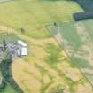
Oblique aerial view. |
10/7/2018 |
Item Level |
|
 |
On-line Digital Images |
SC 1775041 |
John Dewar |
Oblique aerial view of the cropmarks at Leadketty. |
1975 |
Item Level |
|
 |
On-line Digital Images |
SC 1775042 |
John Dewar |
Oblique aerial view of the cropmarks at Leadketty. |
1975 |
Item Level |
|
 |
On-line Digital Images |
SC 2394272 |
Records of the Ordnance Survey, Southampton, Hampshire, England |
Leadketty, NO01NW 33, Ordnance Survey index card, Recto |
1958 |
Item Level |
|
 |
On-line Digital Images |
SC 2394273 |
Records of the Ordnance Survey, Southampton, Hampshire, England |
Leadketty, NO01NW 33, Ordnance Survey index card, page number 1, Recto |
1958 |
Item Level |
|
 |
On-line Digital Images |
SC 2394274 |
Records of the Ordnance Survey, Southampton, Hampshire, England |
Leadketty, NO01NW 33, Ordnance Survey index card, page number 2, Recto |
1958 |
Item Level |
|


