
Pricing Change
New pricing for orders of material from this site will come into place shortly. Charges for supply of digital images, digitisation on demand, prints and licensing will be altered.
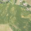
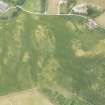
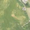
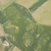
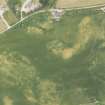
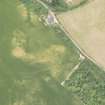
Bourtreebush


Ring Ditch (Period Unassigned)
Site Name Bourtreebush
Classification Ring Ditch (Period Unassigned)
Canmore ID 265136
Site Number NK06SW 81
NGR NK 0049 6117
Datum OSGB36 - NGR
Permalink http://canmore.org.uk/site/265136


- Council Aberdeenshire
- Parish Rathen
- Former Region Grampian
- Former District Banff And Buchan
- Former County Aberdeenshire
NK06SW 81 0049 6117
(Location cited as NK 0049 6117). The well-developed cropmark of a penannular ring-ditch is visible in a field of cereal crop.
(Presumably recorded by air photography: no date of imagery or imagery reference cited).
NMRS, MS/2059.

