|
Photographs and Off-line Digital Images |
H 84975 CS |
RCAHMS Aerial Photography |
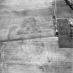
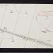
Oblique aerial view centred on the cropmarks of the possible long cist cemetery and pits with the remains of the standing stone adjacent, taken from the SSW. |
31/7/2001 |
Item Level |
|
|
Photographs and Off-line Digital Images |
H 84976 CS |
RCAHMS Aerial Photography |
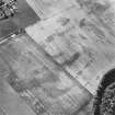
Oblique aerial view centred on the cropmarks of the possible long cist cemetery and pits with the remains of the standing stone adjacent, taken from the SSE. |
31/7/2001 |
Item Level |
|
|
Photographs and Off-line Digital Images |
H 84978 CS |
RCAHMS Aerial Photography |
Oblique aerial view centred on the cropmarks of the possible long cist cemetery and pits with the remains of the standing stone adjacent, taken from the SE. |
31/7/2001 |
Item Level |
|
 |
On-line Digital Images |
SC 1704352 |
RCAHMS Aerial Photography |
Oblique aerial view centred on the cropmarks of the possible long cist cemetery and pits with the remains of the standing stone adjacent, taken from the WNW. |
31/7/2001 |
Item Level |
|
 |
On-line Digital Images |
SC 1704354 |
RCAHMS Aerial Photography |
Oblique aerial view centred on the cropmarks of the possible long cist cemetery and pits with the remains of the standing stone adjacent, taken from the ESE. |
31/7/2001 |
Item Level |
|
 |
On-line Digital Images |
SC 2393656 |
Records of the Ordnance Survey, Southampton, Hampshire, England |
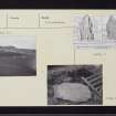
Clach Na Croiche, Balnaguard, NN95SW 3, Ordnance Survey index card, Recto |
1958 |
Item Level |
|
 |
On-line Digital Images |
SC 2393657 |
Records of the Ordnance Survey, Southampton, Hampshire, England |
Clach Na Croiche, Balnaguard, NN95SW 3, Ordnance Survey index card, page number 1, Recto |
1958 |
Item Level |
|
 |
On-line Digital Images |
SC 2393658 |
Records of the Ordnance Survey, Southampton, Hampshire, England |
Clach Na Croiche, Balnaguard, NN95SW 3, Ordnance Survey index card, page number 2, Verso |
1958 |
Item Level |
|
 |
On-line Digital Images |
SC 2393659 |
Records of the Ordnance Survey, Southampton, Hampshire, England |
Clach Na Croiche, Balnaguard, NN95SW 3, Ordnance Survey index card, page number 3, Recto |
1958 |
Item Level |
|
 |
On-line Digital Images |
SC 2393660 |
Records of the Ordnance Survey, Southampton, Hampshire, England |
Clach Na Croiche, Balnaguard, NN95SW 3, Ordnance Survey index card, page number 4, Verso |
1958 |
Item Level |
|
 |
On-line Digital Images |
SC 2393661 |
Records of the Ordnance Survey, Southampton, Hampshire, England |
Clach Na Croiche, Balnaguard, NN95SW 3, Ordnance Survey index card, Recto |
1958 |
Item Level |
|
 |
On-line Digital Images |
SC 2393662 |
Records of the Ordnance Survey, Southampton, Hampshire, England |
Clach Na Croiche, Balnaguard, NN95SW 3, Ordnance Survey index card, Recto |
1958 |
Item Level |
|
|
All Other |
BS 171 |
General Collection |
Slides relating to excavations and research by Professor J M Coles:
Coles Photographs BS 171
1 – 2 Culbin (no date)
3 – 5 Kilmelfort (no date)
6-8 Grandtully (Apr 67)
9-33 Morton
34-48 Miscellaneous Metal Artefacts
49-115 Pitnacree
116 - 118 Lundin Links to N.
119 Dreva to NE.
120 - 121 View from Craik Moor
122 Drumchesters to E. Stone huts
123 Craigie Hill fort. Hut circle…..?
124 Traprain Law
125 - 129 Courthill Dalry
130 Balbirnie circle to SE
131 Balbirnie Cist with C & ring
132 Dowally
133 - 134 Cairnpapple to NW
135 Dunmore NO0724 4198
136 Nether Largie South Cairn Neo.
137 – 138 Balnaguard
139 Inchyra
140 Ardestie Angus souterrain
141 Woden Law
142 – 143 White Meldon
144 - 146 Balfarg
147 Little Trochrie
148 -149 Shien Hill
150 Castlelaw fort view to SW. Souterrain on left.
151 Torwoodlee broch to S
152 -153 Mains of Fordie
154 from White Castle. Traprain
155- 158 Carse group
159 Kindallachan barrow
160 Fortingall barrow
161 Huntingtower Perthshire
162 Strathtay
163 -165 Fortingall
166 -168 Croft Moraig 1974
169 Jura st. stone at Tarbert Lodge
!70 -171 Ballinluig
172 Mains Kenmore (Taymouth) east. 30 by 18m by 2.5m ht.
173 Collessie Fife
174 Gall (Gauls)
175 Ninewells |
c. 1970 |
Batch Level |
|
|
All Other |
551 166/1/1 |
Records of the Ordnance Survey, Southampton, Hampshire, England |
Archaeological site card index ('495' cards) |
1947 |
Sub-Group Level |
|
|
All Other |
551 50/19 |
Papers of Dr Margaret E C Stewart, archaeologist, Perth, Scotland |
Archive from excavation at Clach na Croiche, Balnaguard |
1969 |
Group Level |
|


