
Rousay, Knowe Of Hunclett


Broch (Iron Age)(Possible)
Site Name Rousay, Knowe Of Hunclett
Classification Broch (Iron Age)(Possible)
Canmore ID 2629
Site Number HY42NW 15
NGR HY 41457 27212
Datum OSGB36 - NGR
Permalink http://canmore.org.uk/site/2629


- Council Orkney Islands
- Parish Rousay And Egilsay
- Former Region Orkney Islands Area
- Former District Orkney
- Former County Orkney
HY42NW 15 4144 2722.
(HY 4144 2722) Knowe of Hunclett (NAT)
Broch (NR) (remains of)
OS 1:10,000 1977.
A turf-covered mound, 10 ft high, showing at one place a fragment, 3 ft long and 1 ft high, of a carefully built inner face of a curving wall, suggestive of a broch. The internal diameter is from 30 to 33 ft, and the walls were probably not less than 10 to 12 ft wide. There is a slight hollow on the top.
RCAHMS 1946. Visited 1928.
Knowe of Hunclett: The turf-covered remains of a broch, generally as described by the RCAHM. There are traces of walling outside to the S suggestive of secondary buildings.
Resurveyed at 1:2500.
Visited by OS(ISS) 9 October 1972.
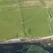
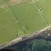
Aerial Photography (1971)
Oblique aerial photographs of the possible broch at Knowe of Hunclett, Rousay, Orkney Island, taken by Mr John Dewar in 1971.
Field Visit (September 1980)
This is a very extensive site indeed. Broch mound generally as described, but the broad platform-mound from which it rises continues W into the next field (where it is left rough as unploughable) where it extends some 70m from the field-wall. General height of platform above surroundings is some 1.5m. It is hummocky and quarried but there are copious exposures of walling indicating a great complex of subsidiary buildings. At extreme W the area is bounded by a curving ditch 2.2m deep and 3-4m wide, possibly accentuated by quarrying. On its inner lip is a stone wall suggestive of a fortified enclosure. Some stonework also appears W of the ditch where there may be an outer wall. Some exposure of this in the shore banks but in general these are grassed and sea erosion seems not to be active.
Information from Orkney SMR (RGL) Sep 80.
Field Visit (September 1980)
Knowe of Hunclett HY 4145 2722 HY42NW 15
Very extensive site with many exposures of stonework indicating subsidiary buildings surrounding a broch; the broch is represented by a mound and the whole by a broad platform which is delimited on the W by a curving ditch (3m to 4m wide and 2.2m deep), on inner lip of which is a stone wall.
RCAHMS 1982, visited September 1980
(RCAHMS 1946, ii, p. 201, No. 555; OR 516)
Publication Account (2002)
HY42 7 KNOWE OF HUNCLETT
HY/41442722
Probable broch on Rousay consisting of a turf-covered mound about 3 m high and 30 m from the shore. At one point a short segment of the inner face of a curved dry stone wall is visible, and it suggests a building which might have an internal diameter of 9.15 - 10.07 m (30-33 ft.) [2], which may stand on a platform [1]. There are many traces of outbuildings.
Sources: 1. OS card HY 42 NW 15: 2. RCAHMS 1946, 2, no. 555, 201: 3. Lamb 1982, 22: 4. Hedges et al. 1987, 110.
E W MacKie 2002

