
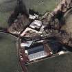
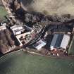
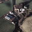
Stoneypath, Steading, Cart Shed


Cart Shed (Period Unassigned), Farmstead (Period Unassigned)
Site Name Stoneypath, Steading, Cart Shed
Classification Cart Shed (Period Unassigned), Farmstead (Period Unassigned)
Alternative Name(s) Nw Range
Canmore ID 262368
Site Number NT67SW 21.02
NGR NT 61624 71107
Datum OSGB36 - NGR
Permalink http://canmore.org.uk/site/262368


- Council East Lothian
- Parish Whittingehame
- Former Region Lothian
- Former District East Lothian
- Former County East Lothian
NT67SW 21.02 61624 71107
A courtyard farmstead comprising one partially roofed long building annotated Ruin, three roofed buildings and four enclosures are depicted on the 1st edition of the OS 6-inch map (Haddingtonshire 1855, sheet 11). Four roofed buildings and seven enclosures are shown on the current edition of the OS 1:10000 map (1982).
Information from RCAHMS (SAH) 29 September 2000

