
Innerpeffray West


Temporary Camp (Roman)
Site Name Innerpeffray West
Classification Temporary Camp (Roman)
Canmore ID 26014
Site Number NN91NW 25
NGR NN 9081 1819
NGR Description NN 9081 and 1819 and NN 9079 1840
Datum OSGB36 - NGR
Permalink http://canmore.org.uk/site/26014


- Council Perth And Kinross
- Parish Crieff
- Former Region Tayside
- Former District Perth And Kinross
- Former County Perthshire
NN91NW 25 907 182.
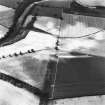
The greater part of the perimeter of the camp has now also been traced, including three of the gates. Its approximate dimensions are 2,100ft from east to west by 1,400ft.
J K St Joseph 1958
No trace on ground.
Visited by OS 5 June 1967.
Excavation (2007)
NN 9079 1840 Air photography has long shown that the Roman Gask frontier road in crossing through the temporary camp passes through the defences, rather than the gates. This suggested that the two could never have been in operation at the same time, and a trench was dug to study their history by cutting one of two points at which they intersect. The camp belongs to the so-called ‘63 acre’ series which is assumed to date from the Antonine or Several period, whereas the road was thought to date to the later 1st-century when the Gask frontier itself was built. Both were poorly dated, however, and there has been speculation in the past that the well constructed, all-weather Roman road might be Antonine in date, with the 1st-century frontier using a lighter track. This was supported by the excavated evidence, because the road was clearly shown to postdate the camp, being constructed over its filled in ditch. This sequence would help to explain two phenomena that have been something of a mystery in the past: firstly, why the road ends at the Tay and does not run on to the 1st-century legionary fortress of Inchtuthil, and, secondly the apparent lack of a similarly well constructed road network to link the Gask line to the so-called ‘Glenblocker’ forts to its N.
Archive deposited with the The Roman Gask Project.
Funder: The Roman Gask Project.
Publication Account (17 December 2011)
The two camps at Innerpeffray were recorded from the air by St Joseph in 1945 (St Joseph 1951a: 63), but may have been noted earlier by Horsley, who drew a large earthwork entitled ‘Innerpeffray camp’ with a smaller camp attached to its west side (1732: opp. 44). These may well have represented the remains of the two camps now known as Innerpeffray East and West, and both now recorded through cropmarks.
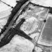
The two camps lie on gently sloping ground above the River Earn, across from the fort and camps at Strageath. The presumed Gask Roman road runs to the north of the east camp, where it is accompanied by a watchtower (Parkneuk), and cuts through the northern corner of the west camp.
The east camp is the larger of the two and irregular in form, measuring about 860m from east to west by about 710m (although is up to 910m in length in places and much narrower at the west end than the east); it enclosed almost 56ha (138 acres). Entrance gaps with tituli are visible in the centre of the east side and in the eastern part of the south side. Part of the northern rampart and ditch of the camp is visible as an upstanding earthwork in woodland. St Joseph excavated a section here in 1966 and recorded that the ditch was about 3.6m in width and nearly 1.2m in depth with a drainage channel in the bottom. The upstanding rampart was composed of clean, fresh upcast material (RCAHMS St Joseph Collection: Notebook 4).
Innerpeffray West lies immediately to the west and is also slightly irregular in form, measuring about 660m from WSW to ENE by 400m, enclosing about 25.5ha (63 acres). Entrance gaps with tituli are visible on the eastern part of the SSE and NNW sides. An annexe is visible on the east side of the camp, almost intersecting with Innerpeffray East; this measures at least 92m by 125m and encloses a minimum area of 1.14ha (2.8 acres).
St Joseph rather ambiguously referred to an additional two camps at Innerpeffray, one within the camp (unspecified), attached to the south rampart, and another attached outside the east rampart (1958: 90). The assumption has been that he was referring to Innerpeffray East, as he referred to the ‘large camp’, although this did follow a reference to Innerpeffray West, which has an annexe on its eastern side. No additional ‘camps’ were recorded in association with the East camp by the Ordnance Survey in 1967 (OS Recorder 1967), and none has been recorded in the literature since. St Joseph’s unpublished plans of the East camp do not illustrate the location of these features (RCAHMS DC 37391). Neither is visible on the aerial photographs of the east camp, and it therefore appears that St Joseph must have been referring to the camp at Innerpeffray West. Though there are a number of linear cropmarks within the East camp and also adjacent to its south-east corner, these do not appear to be Roman and have the appearance of more recent field boundaries. At Innerpeffray West, as well as the annexe attached to the ENE side, there are a number of linear cropmarks around the ruined Innerpeffray Castle in its south corner, which may be the remains of garden features. St Joseph restated the presence of two annexes on one of the Innerpeffray camps in 1965, and the west therefore seems the more likely candidate (St Joseph 1965: 81n).
Innerpeffray West lies astride the Roman road, indicated by a linear cropmark which continues the line through Innerpeffray Wood, and cuts across its northern corner. To the south of this line lies a further linear cropmark and some possible quarry pits. The relationship between the road and camp was tested by excavation in 2007, demonstrating that the road was the later of the two (Woolliscroft 2007). While it has not been established beyond doubt that the road recorded is Roman in date (it could represent the route of the medieval road in this area), the findings shed light on the potential dating of the western camp (see Chapter 10).
R H Jones

