 |
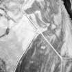
On-line Digital Images |
DP 018109 |
RCAHMS Aerial Photography Digital |
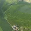
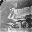
Oblique aerial view centred on the cropmarks of the rig, pits and possible barrows with the cropmarks of the enclosure and ring-ditches and the farmhouse and farmsteading adjacent, taken from the NW. |
6/7/2006 |
Item Level |
|
 |
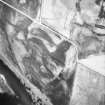
On-line Digital Images |
DP 018110 |
RCAHMS Aerial Photography Digital |
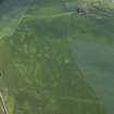
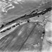
Oblique aerial view centred on the cropmarks of the rig, pits and possible barrows with the cropmarks of the enclosure and ring-ditches and the farmhouse and farmsteading adjacent, taken from the WSW. |
6/7/2006 |
Item Level |
|
 |
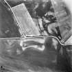
On-line Digital Images |
DP 018111 |
RCAHMS Aerial Photography Digital |
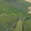
Oblique aerial view centred on the cropmarks of the rig with the cropmarks of the rig, pits, possible barrows, ring-ditches and enclosure and the farmhouse and farmsteading adjacent, taken from the W. |
6/7/2006 |
Item Level |
|
 |
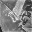
On-line Digital Images |
SC 1703192 |
RCAHMS Aerial Photography |
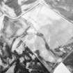
Oblique aerial view. |
1984 |
Item Level |
|
 |
On-line Digital Images |
SC 1703193 |
RCAHMS Aerial Photography |
Oblique aerial view. |
1984 |
Item Level |
|
 |
On-line Digital Images |
SC 1703194 |
RCAHMS Aerial Photography |
Oblique aerial view. |
1984 |
Item Level |
|
 |
On-line Digital Images |
SC 1703222 |
RCAHMS Aerial Photography |
Oblique aerial view. |
1992 |
Item Level |
|
 |
On-line Digital Images |
SC 1703223 |
RCAHMS Aerial Photography |
Oblique aerial view. |
1992 |
Item Level |
|
 |
On-line Digital Images |
SC 1703224 |
RCAHMS Aerial Photography |
Oblique aerial view. |
1992 |
Item Level |
|
 |
On-line Digital Images |
SC 1703226 |
RCAHMS Aerial Photography |
Filed in archaeology box file |
1992 |
Item Level |
|
 |
On-line Digital Images |
SC 2392513 |
Records of the Ordnance Survey, Southampton, Hampshire, England |
Haugh Of Aberuthven, NN91NE 32, Ordnance Survey index card, Recto |
1958 |
Item Level |
|


