
St Serf's Bridge


Bridge (Period Unassigned)
Site Name St Serf's Bridge
Classification Bridge (Period Unassigned)
Canmore ID 25941
Site Number NN90SE 2
NGR NN 9989 0321
Datum OSGB36 - NGR
Permalink http://canmore.org.uk/site/25941


- Council Perth And Kinross
- Parish Glendevon
- Former Region Tayside
- Former District Perth And Kinross
- Former County Perthshire
NN90SE 2 9989 0321.
(NN 9989 0321) St Serf's Bridge (NR)
OS 6" map, (1959)
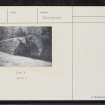
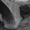
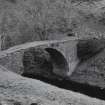
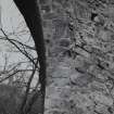
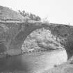
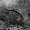
The remains of an old stone bridge of one arch which formerly carried the road to Perth by Dunning before the turnpike was built in the early 19th century. Its narrowness suggests a pack horse bridge. The present bridge was built after 1736.
Name Book 1859; OSA 1796.
St Serf's Bridge, which is still suitable for farm vehicles or pedestrians, is 3.0m wide with no side walls. The name is still known locally.
Visited by OS (R D) 28 June 1967.
This bridge is now submerged, following the construction of Castlehill Reservoir.
Visited by OS (R D) 28 June 1967.

