
Saverock


Burnt Mound (Prehistoric)
Site Name Saverock
Classification Burnt Mound (Prehistoric)
Alternative Name(s) Burn Of Hatston; Hatston Airfield
Canmore ID 2574
Site Number HY41SW 6
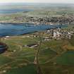
NGR HY 4348 1280
Datum OSGB36 - NGR
Permalink http://canmore.org.uk/site/2574


- Council Orkney Islands
- Parish Kirkwall And St Ola
- Former Region Orkney Islands Area
- Former District Orkney
- Former County Orkney
HY41SW 6 4348 1280.
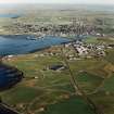
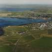
There is a burnt mound near Saverock about midway between the earth-house (ORK.102 SW 6) and the public road.
RCAHMS 1946.
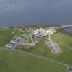
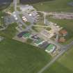
This mound is 2.0m. high and is situated on the disused Hatston aerodrome, at HY 4348 1280. It is grass covered and appears to be undisturbed except for a shallow trench that has been dug across it. This trench shows the surface of the mound to be composed of fire blackened earth and small burnt stones.
Surveyed at 1:2500.
Visited by OS (GHP) 3 April 1964.
This burnt mound is still in the condition reported above, despite lying close to several areas of development that are taking place, not least the dumping of earth in an adjacent field.
Visited by RCAHMS (DE) May 1996.
Field Visit (3 April 1964)
This mound is 2.0m. high and is situated on the disused Hatston aerodrome, at HY 4348 1280. It is grass covered and appears to be undisturbed except for a shallow trench that has been dug across it. This trench shows the surface of the mound to be composed of fire blackened earth and small burnt stones.
Surveyed at 1:2500.
Visited by OS (GHP) 3 April 1964.
Field Visit (May 1996)
This burnt mound is still in the condition reported above, despite lying close to several areas of development that are taking place, not least the dumping of earth in an adjacent field.
Visited by RCAHMS (DE) May 1996.
Archaeological Evaluation (7 January 2008 - 15 January 2008)
HY 4350 1275 Work was conducted before development on an area adjacent to the Hatston Pier access road, on 7–15 January 2008. The work was required due to the presence of a burnt mound (HY41SW 6). The burnt mound will be avoided by the development, but an evaluation of the subsurface remains associated with it was required.
Five trenches were opened by machine covering 522m2 (5%) of the area. The trenches recorded nothing of archaeological significance, apart from the burnt mound, but showed the surrounding ground surface to be the result of considerable modern makeup, with the old ground surface surviving undisturbed below.
The burnt mound was accurately plotted in advance of the development and it was recommended that a 5m buffer zone should be left around it. It proved to be considerably larger than previously thought, extending up to 3.6–4.7m beyond its visible surface area and occupying a natural knoll in a low-lying and waterlogged landscape, with the old ground surface up to 1.70m below the modern surface.
Archive: RCAHMS (intended). Report: Orkney SMR and RCAHMS
Funder: Orkney Islands Council
Caz Mamwell (ORCA), 2008

