
Loch Tummel


Crannog (Period Unassigned)(Possible)
Site Name Loch Tummel
Classification Crannog (Period Unassigned)(Possible)
Alternative Name(s) An T-eilean
Canmore ID 25683
Site Number NN85NW 1
NGR NN 8119 5962
Datum OSGB36 - NGR
Permalink http://canmore.org.uk/site/25683


- Council Perth And Kinross
- Parish Blair Atholl
- Former Region Tayside
- Former District Perth And Kinross
- Former County Perthshire
NN85NW 1 8119 5962.
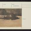
In the NW corner of Loch Tummel, there is a small island, partly artificial, on which Duncan Ravar M'Donald, the chief of the Clan Donnachie or Robertsons, built a strong house and a garden, which gave the name of Port-an-eilein, or the Fort of the Island, to that place (Statistical Account [OSA] 1792) (An t-Eilean is published on OS 6" at NN 8119 5962).
Blundell describes the island as 50 yds by 35 yds, standing in about 7' of water, but there is a deep channel between it and the shore. Carefully-laid stones appear to rest on trees.
F O Blundell 1913
An island formerly at NN 8119 5961 (OS 6" map, 1900) is known locally to be the one described by the OSA. It is now submerged since the loch was dammed by the Hydro Board. Recently, however it was briefly exposed when the water level was lowered and Mrs Torry (Port an Eilean Hotel, Loch Tummel) saw stone slabs which she thought were steps, on the N edge of the island. No further examination was possible at the time.
Visited by OS (JM) 15 November 1974
In 2004, a new initiative was set up to examine crannogs in Perthshire. The county has a wide range of geological conditions and the difference in types of lochs reflects this. Some are shallow with farmland and natural woodlands while others are deeper, often with more barren surroundings. The range is likely to produce crannogs of different forms and possibly different functions. The surviving Pont manuscript maps (1580s-90s) and the Blaeu atlas (1654) show many thousands of settlements, including loch dwellings. The work in the summer of 2004 involved surveying a series of these islands and, where possible, collecting samples for dating evidence. The results produced a range of dates from the Early Iron Age up to the recent past. All the dates quoted are preliminary and so, at present, have no laboratory number.
NN 812 596 Loch Tummel, Port an Eilean. In 1913, the raising of Loch Tummel for a hydro-electric power scheme resulted in the drowning of an island off Port an Eilean (NN85NW 1). According to the literature the site was inhabited from the 15th century until the middle of the 17th century, and was described as one of the area's main strengths in the Blaeu atlas. Early maps and photographs show the position of the site.
The top of the site is now 3m under water and is covered with the stumps of trees cut down before submergence. The remains are still very obvious of a well-made flagstone floor with a path leading to a flight of steps that went down to the loch bed, some 2m deeper. One of a number of upright timbers at the bottom of the stairs was sampled and produced a date of 110±50 BP (AD 1840).
Sponsors: Perth & Kinross Heritage Trust, Scottish Trust for Underwater Archaeology, Mr Halliwell, Tom Coope, Mr Brian Souter, Drummond Estates, Mr Orrock.
N Dixon and M Shelley 2004

