
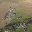
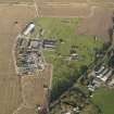
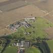
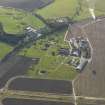
Wigtown Airfield, Technical Site


Air Raid Shelter(S) (20th Century), Building(S) (20th Century), Decontamination Building (20th Century), Hut(S) (19th Century)-(20th Century)
Site Name Wigtown Airfield, Technical Site
Classification Air Raid Shelter(S) (20th Century), Building(S) (20th Century), Decontamination Building (20th Century), Hut(S) (19th Century)-(20th Century)
Alternative Name(s) Baldoon Airfield
Canmore ID 256109
Site Number NX45SW 41.04
NGR NX 43333 52923
Datum OSGB36 - NGR
Permalink http://canmore.org.uk/site/256109


- Council Dumfries And Galloway
- Parish Kirkinner
- Former Region Dumfries And Galloway
- Former District Wigtown
- Former County Wigtownshire
NX45SW 41.04 43333 52923
A decontamination centre is situated in the technical are of the airfield about 179m NE of East Mains of Baldoon farmsteading. Though not examined closely on the date of visit, it is proably a type J centre.
The centre is visible on a vertical air photograph (106G/Scot/UK 42, 4212, flown 4 May 1946), amongst several other buildings in the technical site.
Visited by RCAHMS (DE), March 2004

