
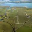
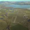
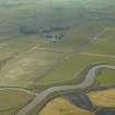
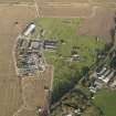
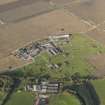
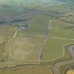
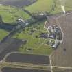
Wigtown Airfield, Technical Site


Control Tower (20th Century)
Site Name Wigtown Airfield, Technical Site
Classification Control Tower (20th Century)
Alternative Name(s) Baldoon Airfield
Canmore ID 256108
Site Number NX45SW 41.03
NGR NX 43317 53268
Datum OSGB36 - NGR
Permalink http://canmore.org.uk/site/256108


- Council Dumfries And Galloway
- Parish Kirkinner
- Former Region Dumfries And Galloway
- Former District Wigtown
- Former County Wigtownshire
NX45SW 41.03 43317 53268
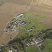
The control/watch tower is situated about 98m N of the most easterly concrete base for an aircraft hangar. Of two storeys with a viewing platform and built of concrete and brick.
The tower was scheduled for demolition in the 1980s, but was still extant when visited in 2004.
The control tower is visible on a vertical air photograph (106G/Scot/UK 42, 4212, flown 4 May 1946), which shows that the recognition letters at that date were 'GO'. The letteres were later noted as 'JO' (Smith 1984).
Information from RCAHMS (DE), April 2006

