
Eigg, Grulin


Dun (Prehistoric)
Site Name Eigg, Grulin
Classification Dun (Prehistoric)
Canmore ID 255793
Site Number NM48SE 40
NGR NM 45440 84173
Datum OSGB36 - NGR
Permalink http://canmore.org.uk/site/255793


- Council Highland
- Parish Small Isles
- Former Region Highland
- Former District Lochaber
- Former County Inverness-shire
Field Visit (16 October 2001)
NM48SE 40 45440 84173
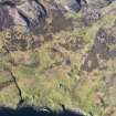
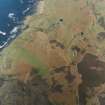
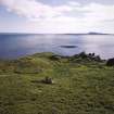
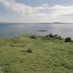
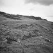
The remains of this dun occupy a rocky boss at the SW edge of Grulin Uachdrach township (NM48SE 7). The ground to the SW falls steeply towards the shore in a series of basalt terraces, but towards the NE the dun faces onto the level terrace occupied by the later township. The wall is only clearly defined on the NW, where a stretch of the outer face stands up to 1.2m high (though still about 1m below the level of the interior), and occasional earthfast stones behind suggest a wall thickness of about 2m. Elsewhere, the wall has been reduced to a band of grass-grown rubble. No entrance is apparent, although the easiest approach to the dun is from the E. The enclosed area is roughly circular, measuring about 20m in diameter, and within it there are three circular platforms, each about 4m in diameter, and a fragment of a later rectangular building.
(EIGG01 589)
Visited by RCAHMS (SDB) 16 October 2002
Measured Survey (15 October 2002)
RCAHMS surveyed the dun at Grulin on 15 October 2002 with plane table and self-reducing alidade at a scale of 1:1000. The plan was later used as the basis for an illustration published in 2016 (Hunter, fig. 3.16).

